You are here: Home > Network List > TA - USArray Transportable Network (new EarthScope stations) Stations List
> Station P61A Hammonton, NJ, USA > Earthquake Result Viewer
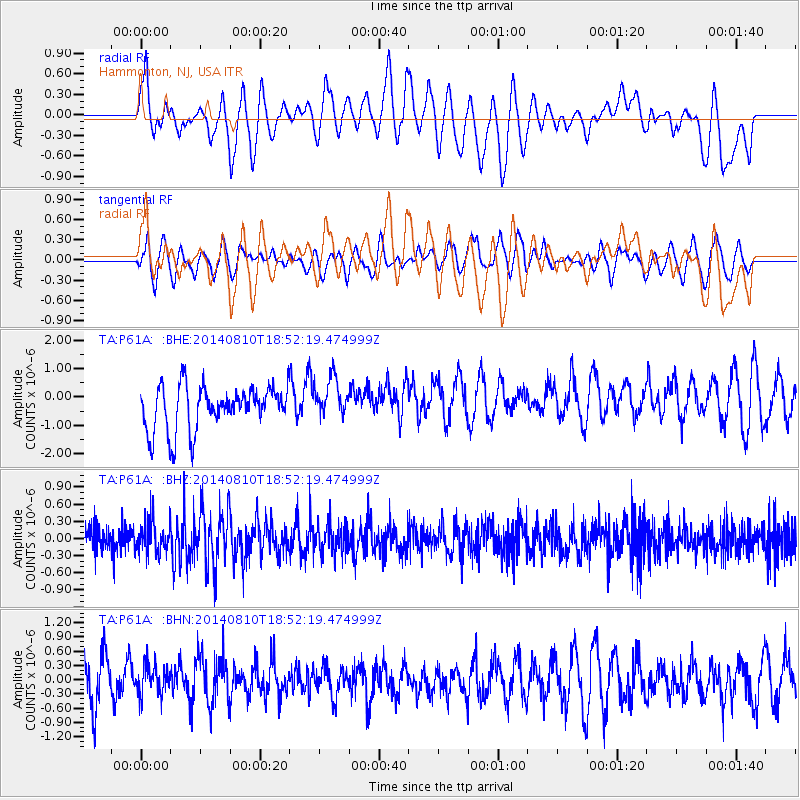
P61A Hammonton, NJ, USA - Earthquake Result Viewer
*The percent match for this event was below the threshold and hence no stack was calculated.
| Earthquake location: |
Gulf Of California |
| Earthquake latitude/longitude: |
27.6/-111.6 |
| Earthquake time(UTC): |
2014/08/10 (222) 18:46:17 GMT |
| Earthquake Depth: |
10 km |
| Earthquake Magnitude: |
5.5 MWW, 5.4 MWB, 5.5 MWC |
| Earthquake Catalog/Contributor: |
NEIC PDE/NEIC COMCAT |
|
| Network: |
TA USArray Transportable Network (new EarthScope stations) |
| Station: |
P61A Hammonton, NJ, USA |
| Lat/Lon: |
39.67 N/74.79 W |
| Elevation: |
22 m |
|
| Distance: |
32.7 deg |
| Az: |
58.904 deg |
| Baz: |
259.823 deg |
| Ray Param: |
$rayparam |
*The percent match for this event was below the threshold and hence was not used in the summary stack. |
|
| Radial Match: |
44.435413 % |
| Radial Bump: |
400 |
| Transverse Match: |
50.121063 % |
| Transverse Bump: |
400 |
| SOD ConfigId: |
769524 |
| Insert Time: |
2014-09-06 17:57:14.259 +0000 |
| GWidth: |
2.5 |
| Max Bumps: |
400 |
| Tol: |
0.001 |
|
Signal To Noise
| Channel | StoN | STA | LTA |
| TA:P61A: :BHZ:20140810T18:52:19.474999Z | 1.3848447 | 2.91705E-7 | 2.1064095E-7 |
| TA:P61A: :BHN:20140810T18:52:19.474999Z | 0.6698917 | 3.1403218E-7 | 4.687805E-7 |
| TA:P61A: :BHE:20140810T18:52:19.474999Z | 0.9272128 | 7.163989E-7 | 7.7263707E-7 |
| Arrivals |
| Ps | |
| PpPs | |
| PsPs/PpSs | |


