You are here: Home > Network List > IM - International Miscellaneous Stations Stations List
> Station PD31 PDAR Array, Pinedale, WY, USA > Earthquake Result Viewer
PD31 PDAR Array, Pinedale, WY, USA - Earthquake Result Viewer
| Earthquake location: |
Near Coast Of Central Chile |
| Earthquake latitude/longitude: |
-32.7/-71.4 |
| Earthquake time(UTC): |
2014/08/23 (235) 22:32:23 GMT |
| Earthquake Depth: |
32 km |
| Earthquake Magnitude: |
6.4 MWW, 6.6 MWP |
| Earthquake Catalog/Contributor: |
NEIC PDE/NEIC COMCAT |
|
| Network: |
IM International Miscellaneous Stations |
| Station: |
PD31 PDAR Array, Pinedale, WY, USA |
| Lat/Lon: |
42.77 N/109.56 W |
| Elevation: |
2219 m |
|
| Distance: |
82.9 deg |
| Az: |
332.7 deg |
| Baz: |
148.322 deg |
| Ray Param: |
0.04655394 |
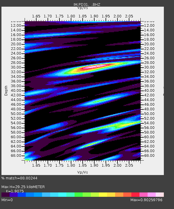
| Estimated Moho Depth: |
29.25 km |
| Estimated Crust Vp/Vs: |
1.91 |
| Assumed Crust Vp: |
6.161 km/s |
| Estimated Crust Vs: |
3.23 km/s |
| Estimated Crust Poisson's Ratio: |
0.31 |
|
| Radial Match: |
88.80244 % |
| Radial Bump: |
400 |
| Transverse Match: |
85.665276 % |
| Transverse Bump: |
400 |
| SOD ConfigId: |
769524 |
| Insert Time: |
2014-09-06 22:51:50.113 +0000 |
| GWidth: |
2.5 |
| Max Bumps: |
400 |
| Tol: |
0.001 |
|

Signal To Noise
| Channel | StoN | STA | LTA |
| IM:PD31: :BHZ:20140823T22:44:13.423994Z | 15.061566 | 2.9587511E-8 | 1.964438E-9 |
| IM:PD31: :BHN:20140823T22:44:13.423994Z | 4.8177657 | 7.164145E-9 | 1.4870264E-9 |
| IM:PD31: :BHE:20140823T22:44:13.423994Z | 5.937353 | 9.878967E-9 | 1.6638672E-9 |
| Arrivals |
| Ps | 4.4 SECOND |
| PpPs | 14 SECOND |
| PsPs/PpSs | 18 SECOND |


