You are here: Home > Network List > LD - Lamont-Doherty Cooperative Seismographic Network Stations List
> Station FLET Fletcher, VT > Earthquake Result Viewer
FLET Fletcher, VT - Earthquake Result Viewer
| Earthquake location: |
Near Coast Of Central Chile |
| Earthquake latitude/longitude: |
-32.7/-71.4 |
| Earthquake time(UTC): |
2014/08/23 (235) 22:32:23 GMT |
| Earthquake Depth: |
32 km |
| Earthquake Magnitude: |
6.4 MWW, 6.6 MWP |
| Earthquake Catalog/Contributor: |
NEIC PDE/NEIC COMCAT |
|
| Network: |
LD Lamont-Doherty Cooperative Seismographic Network |
| Station: |
FLET Fletcher, VT |
| Lat/Lon: |
44.72 N/72.95 W |
| Elevation: |
366 m |
|
| Distance: |
77.1 deg |
| Az: |
358.856 deg |
| Baz: |
178.646 deg |
| Ray Param: |
0.05052655 |
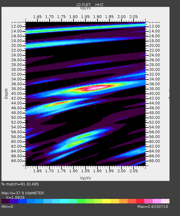
| Estimated Moho Depth: |
37.5 km |
| Estimated Crust Vp/Vs: |
1.89 |
| Assumed Crust Vp: |
6.419 km/s |
| Estimated Crust Vs: |
3.392 km/s |
| Estimated Crust Poisson's Ratio: |
0.31 |
|
| Radial Match: |
91.81465 % |
| Radial Bump: |
281 |
| Transverse Match: |
81.68488 % |
| Transverse Bump: |
400 |
| SOD ConfigId: |
769524 |
| Insert Time: |
2014-09-06 22:53:35.468 +0000 |
| GWidth: |
2.5 |
| Max Bumps: |
400 |
| Tol: |
0.001 |
|

Signal To Noise
| Channel | StoN | STA | LTA |
| LD:FLET: :HHZ:20140823T22:43:42.249983Z | 16.53971 | 1.5511686E-6 | 9.378451E-8 |
| LD:FLET: :HHN:20140823T22:43:42.249983Z | 7.301909 | 5.9635255E-7 | 8.167077E-8 |
| LD:FLET: :HHE:20140823T22:43:42.249983Z | 2.3024423 | 1.74774E-7 | 7.590809E-8 |
| Arrivals |
| Ps | 5.4 SECOND |
| PpPs | 16 SECOND |
| PsPs/PpSs | 22 SECOND |


