You are here: Home > Network List > N4 - Central and EAstern US Network Stations List
> Station W52A Murphy, NC, USA > Earthquake Result Viewer
W52A Murphy, NC, USA - Earthquake Result Viewer
| Earthquake location: |
Near Coast Of Central Chile |
| Earthquake latitude/longitude: |
-32.7/-71.4 |
| Earthquake time(UTC): |
2014/08/23 (235) 22:32:23 GMT |
| Earthquake Depth: |
32 km |
| Earthquake Magnitude: |
6.4 MWW, 6.6 MWP |
| Earthquake Catalog/Contributor: |
NEIC PDE/NEIC COMCAT |
|
| Network: |
N4 Central and EAstern US Network |
| Station: |
W52A Murphy, NC, USA |
| Lat/Lon: |
35.09 N/83.93 W |
| Elevation: |
519 m |
|
| Distance: |
68.5 deg |
| Az: |
348.964 deg |
| Baz: |
168.649 deg |
| Ray Param: |
0.056241542 |
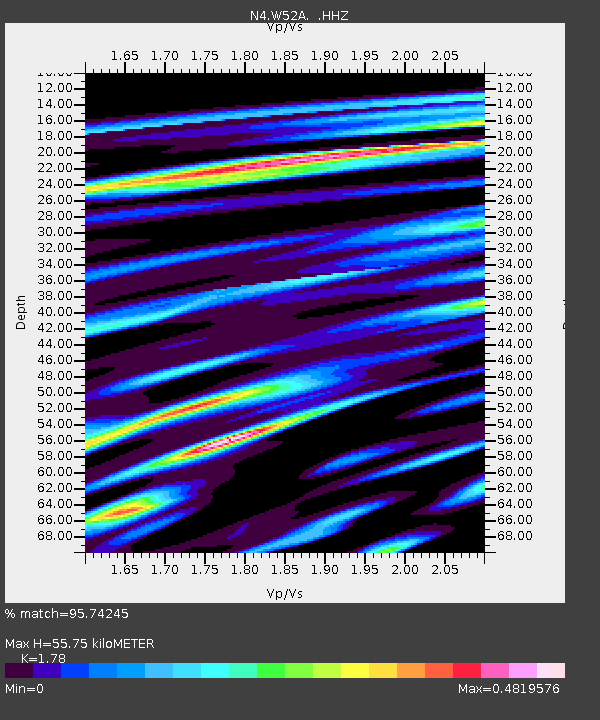
| Estimated Moho Depth: |
55.75 km |
| Estimated Crust Vp/Vs: |
1.78 |
| Assumed Crust Vp: |
6.35 km/s |
| Estimated Crust Vs: |
3.567 km/s |
| Estimated Crust Poisson's Ratio: |
0.27 |
|
| Radial Match: |
95.74245 % |
| Radial Bump: |
362 |
| Transverse Match: |
84.168236 % |
| Transverse Bump: |
400 |
| SOD ConfigId: |
769524 |
| Insert Time: |
2014-09-06 22:57:25.120 +0000 |
| GWidth: |
2.5 |
| Max Bumps: |
400 |
| Tol: |
0.001 |
|

Signal To Noise
| Channel | StoN | STA | LTA |
| N4:W52A: :HHZ:20140823T22:42:51.30998Z | 30.74135 | 1.8848908E-6 | 6.131451E-8 |
| N4:W52A: :HHN:20140823T22:42:51.30998Z | 11.2712 | 8.7331995E-7 | 7.748243E-8 |
| N4:W52A: :HHE:20140823T22:42:51.30998Z | 3.5064046 | 2.7775337E-7 | 7.921315E-8 |
| Arrivals |
| Ps | 7.1 SECOND |
| PpPs | 24 SECOND |
| PsPs/PpSs | 31 SECOND |


