You are here: Home > Network List > N4 - Central and EAstern US Network Stations List
> Station Y49A Blount Mountain, AL, USA > Earthquake Result Viewer
Y49A Blount Mountain, AL, USA - Earthquake Result Viewer
| Earthquake location: |
Near Coast Of Central Chile |
| Earthquake latitude/longitude: |
-32.7/-71.4 |
| Earthquake time(UTC): |
2014/08/23 (235) 22:32:23 GMT |
| Earthquake Depth: |
32 km |
| Earthquake Magnitude: |
6.4 MWW, 6.6 MWP |
| Earthquake Catalog/Contributor: |
NEIC PDE/NEIC COMCAT |
|
| Network: |
N4 Central and EAstern US Network |
| Station: |
Y49A Blount Mountain, AL, USA |
| Lat/Lon: |
33.86 N/86.41 W |
| Elevation: |
362 m |
|
| Distance: |
67.7 deg |
| Az: |
346.517 deg |
| Baz: |
166.335 deg |
| Ray Param: |
0.056736767 |
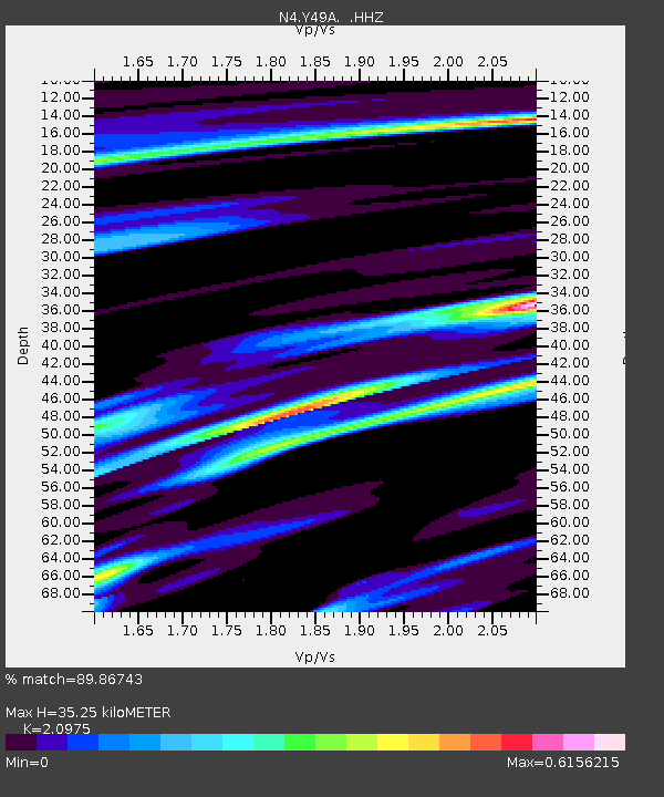
| Estimated Moho Depth: |
35.25 km |
| Estimated Crust Vp/Vs: |
2.10 |
| Assumed Crust Vp: |
6.565 km/s |
| Estimated Crust Vs: |
3.13 km/s |
| Estimated Crust Poisson's Ratio: |
0.35 |
|
| Radial Match: |
89.86743 % |
| Radial Bump: |
377 |
| Transverse Match: |
75.76133 % |
| Transverse Bump: |
400 |
| SOD ConfigId: |
769524 |
| Insert Time: |
2014-09-06 22:57:33.777 +0000 |
| GWidth: |
2.5 |
| Max Bumps: |
400 |
| Tol: |
0.001 |
|

Signal To Noise
| Channel | StoN | STA | LTA |
| N4:Y49A: :HHZ:20140823T22:42:46.55998Z | 17.796999 | 1.3040653E-6 | 7.327445E-8 |
| N4:Y49A: :HHN:20140823T22:42:46.55998Z | 10.688961 | 5.5062316E-7 | 5.151325E-8 |
| N4:Y49A: :HHE:20140823T22:42:46.55998Z | 5.556593 | 2.4219023E-7 | 4.3586102E-8 |
| Arrivals |
| Ps | 6.1 SECOND |
| PpPs | 16 SECOND |
| PsPs/PpSs | 22 SECOND |


