You are here: Home > Network List > N4 - Central and EAstern US Network Stations List
> Station Z51A Franklin, GA, USA > Earthquake Result Viewer
Z51A Franklin, GA, USA - Earthquake Result Viewer
| Earthquake location: |
Near Coast Of Central Chile |
| Earthquake latitude/longitude: |
-32.7/-71.4 |
| Earthquake time(UTC): |
2014/08/23 (235) 22:32:23 GMT |
| Earthquake Depth: |
32 km |
| Earthquake Magnitude: |
6.4 MWW, 6.6 MWP |
| Earthquake Catalog/Contributor: |
NEIC PDE/NEIC COMCAT |
|
| Network: |
N4 Central and EAstern US Network |
| Station: |
Z51A Franklin, GA, USA |
| Lat/Lon: |
33.32 N/85.17 W |
| Elevation: |
249 m |
|
| Distance: |
66.9 deg |
| Az: |
347.474 deg |
| Baz: |
167.385 deg |
| Ray Param: |
0.057232164 |
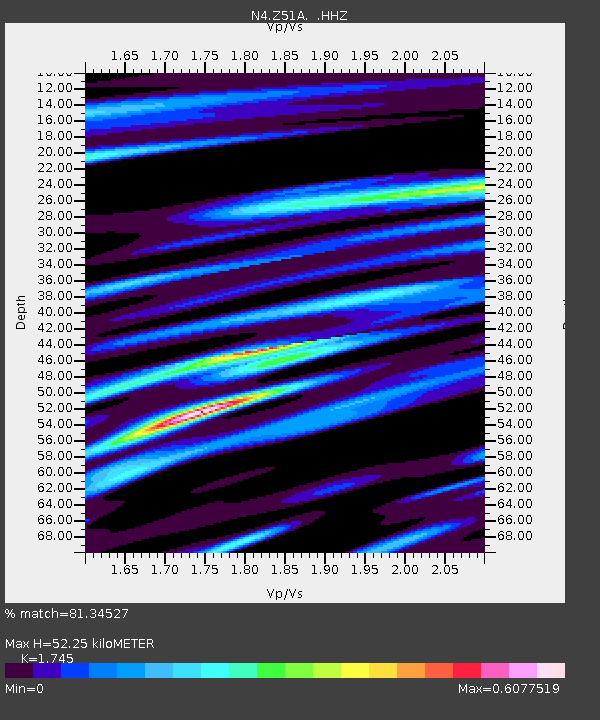
| Estimated Moho Depth: |
52.25 km |
| Estimated Crust Vp/Vs: |
1.75 |
| Assumed Crust Vp: |
6.719 km/s |
| Estimated Crust Vs: |
3.851 km/s |
| Estimated Crust Poisson's Ratio: |
0.26 |
|
| Radial Match: |
81.34527 % |
| Radial Bump: |
400 |
| Transverse Match: |
63.832855 % |
| Transverse Bump: |
400 |
| SOD ConfigId: |
769524 |
| Insert Time: |
2014-09-06 22:57:43.606 +0000 |
| GWidth: |
2.5 |
| Max Bumps: |
400 |
| Tol: |
0.001 |
|

Signal To Noise
| Channel | StoN | STA | LTA |
| N4:Z51A: :HHZ:20140823T22:42:41.759993Z | 24.068933 | 1.3635008E-6 | 5.6649824E-8 |
| N4:Z51A: :HHN:20140823T22:42:41.759993Z | 6.5904584 | 6.16932E-7 | 9.3609884E-8 |
| N4:Z51A: :HHE:20140823T22:42:41.759993Z | 1.7507342 | 1.9212035E-7 | 1.0973702E-7 |
| Arrivals |
| Ps | 6.1 SECOND |
| PpPs | 20 SECOND |
| PsPs/PpSs | 26 SECOND |


