You are here: Home > Network List > TJ - Tajikistan National Seismic Network Stations List
> Station IGRN Igron, Tajikistan > Earthquake Result Viewer
IGRN Igron, Tajikistan - Earthquake Result Viewer
| Earthquake location: |
Taiwan Region |
| Earthquake latitude/longitude: |
24.1/122.5 |
| Earthquake time(UTC): |
2015/04/20 (110) 11:45:14 GMT |
| Earthquake Depth: |
36 km |
| Earthquake Magnitude: |
6.2 MWP |
| Earthquake Catalog/Contributor: |
NEIC PDE/NEIC COMCAT |
|
| Network: |
TJ Tajikistan National Seismic Network |
| Station: |
IGRN Igron, Tajikistan |
| Lat/Lon: |
38.22 N/69.33 E |
| Elevation: |
1284 m |
|
| Distance: |
47.0 deg |
| Az: |
300.524 deg |
| Baz: |
91.446 deg |
| Ray Param: |
0.07019589 |
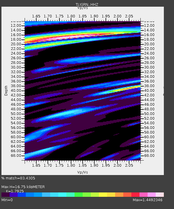
| Estimated Moho Depth: |
16.75 km |
| Estimated Crust Vp/Vs: |
1.79 |
| Assumed Crust Vp: |
6.483 km/s |
| Estimated Crust Vs: |
3.617 km/s |
| Estimated Crust Poisson's Ratio: |
0.27 |
|
| Radial Match: |
83.4305 % |
| Radial Bump: |
400 |
| Transverse Match: |
79.733215 % |
| Transverse Bump: |
400 |
| SOD ConfigId: |
7422571 |
| Insert Time: |
2019-04-18 06:44:06.834 +0000 |
| GWidth: |
2.5 |
| Max Bumps: |
400 |
| Tol: |
0.001 |
|

Signal To Noise
| Channel | StoN | STA | LTA |
| TJ:IGRN: :HHZ:20150420T11:53:11.700009Z | 18.78246 | 2.4608546E-6 | 1.3101877E-7 |
| TJ:IGRN: :HHN:20150420T11:53:11.700009Z | 9.884041 | 1.0622808E-7 | 1.0747434E-8 |
| TJ:IGRN: :HHE:20150420T11:53:11.700009Z | 10.099057 | 1.3423011E-6 | 1.329135E-7 |
| Arrivals |
| Ps | 2.2 SECOND |
| PpPs | 6.8 SECOND |
| PsPs/PpSs | 9.0 SECOND |


