You are here: Home > Network List > TA - USArray Transportable Network (new EarthScope stations) Stations List
> Station H59A Cadyville, NY, USA > Earthquake Result Viewer
H59A Cadyville, NY, USA - Earthquake Result Viewer
| Earthquake location: |
Near Coast Of Central Chile |
| Earthquake latitude/longitude: |
-32.7/-71.4 |
| Earthquake time(UTC): |
2014/08/23 (235) 22:32:23 GMT |
| Earthquake Depth: |
32 km |
| Earthquake Magnitude: |
6.4 MWW, 6.6 MWP |
| Earthquake Catalog/Contributor: |
NEIC PDE/NEIC COMCAT |
|
| Network: |
TA USArray Transportable Network (new EarthScope stations) |
| Station: |
H59A Cadyville, NY, USA |
| Lat/Lon: |
44.65 N/73.69 W |
| Elevation: |
355 m |
|
| Distance: |
77.0 deg |
| Az: |
358.313 deg |
| Baz: |
178.007 deg |
| Ray Param: |
0.050567564 |
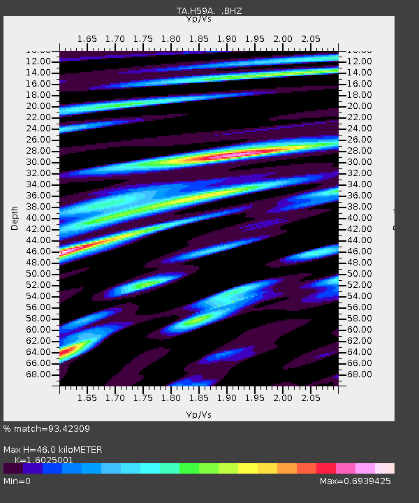
| Estimated Moho Depth: |
46.0 km |
| Estimated Crust Vp/Vs: |
1.60 |
| Assumed Crust Vp: |
6.419 km/s |
| Estimated Crust Vs: |
4.006 km/s |
| Estimated Crust Poisson's Ratio: |
0.18 |
|
| Radial Match: |
93.42309 % |
| Radial Bump: |
400 |
| Transverse Match: |
74.28131 % |
| Transverse Bump: |
400 |
| SOD ConfigId: |
769524 |
| Insert Time: |
2014-09-06 23:07:52.545 +0000 |
| GWidth: |
2.5 |
| Max Bumps: |
400 |
| Tol: |
0.001 |
|

Signal To Noise
| Channel | StoN | STA | LTA |
| TA:H59A: :BHZ:20140823T22:43:41.924971Z | 16.29955 | 1.6062681E-6 | 9.8546785E-8 |
| TA:H59A: :BHN:20140823T22:43:41.924971Z | 7.8991923 | 6.4913445E-7 | 8.217732E-8 |
| TA:H59A: :BHE:20140823T22:43:41.924971Z | 1.0076958 | 1.0842054E-7 | 1.0759252E-7 |
| Arrivals |
| Ps | 4.5 SECOND |
| PpPs | 18 SECOND |
| PsPs/PpSs | 22 SECOND |


