You are here: Home > Network List > YB13 - Continental Dynamics/Cent. Anatolian Tectonics:Surface to Mantle Dynamics During Stations List
> Station AT30 Akpinar,Aksaray,Turkey > Earthquake Result Viewer
AT30 Akpinar,Aksaray,Turkey - Earthquake Result Viewer
| Earthquake location: |
Taiwan Region |
| Earthquake latitude/longitude: |
24.1/122.5 |
| Earthquake time(UTC): |
2015/04/20 (110) 11:45:14 GMT |
| Earthquake Depth: |
36 km |
| Earthquake Magnitude: |
6.2 MWP |
| Earthquake Catalog/Contributor: |
NEIC PDE/NEIC COMCAT |
|
| Network: |
YB Continental Dynamics/Cent. Anatolian Tectonics:Surface to Mantle Dynamics During |
| Station: |
AT30 Akpinar,Aksaray,Turkey |
| Lat/Lon: |
38.76 N/34.00 E |
| Elevation: |
1404 m |
|
| Distance: |
74.2 deg |
| Az: |
305.694 deg |
| Baz: |
71.729 deg |
| Ray Param: |
0.052433353 |
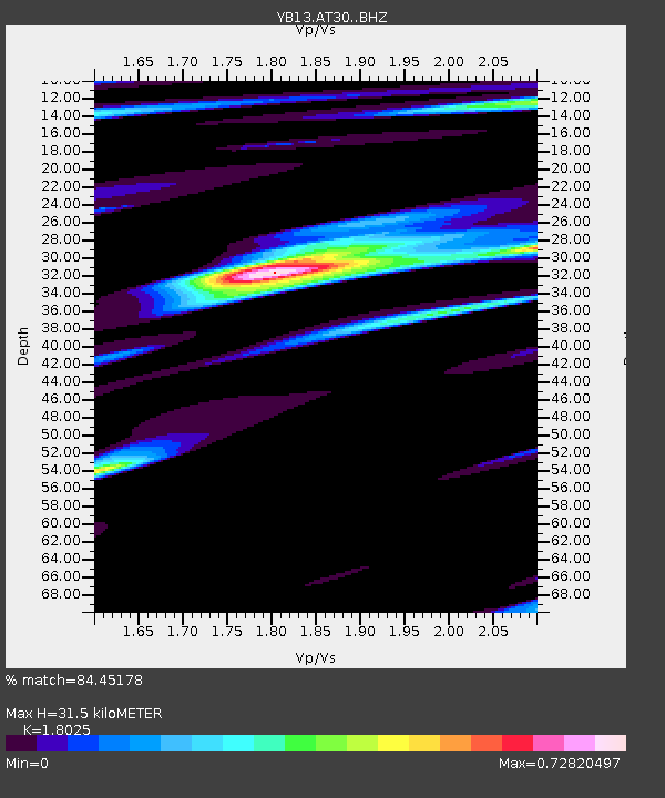
| Estimated Moho Depth: |
31.5 km |
| Estimated Crust Vp/Vs: |
1.80 |
| Assumed Crust Vp: |
6.35 km/s |
| Estimated Crust Vs: |
3.523 km/s |
| Estimated Crust Poisson's Ratio: |
0.28 |
|
| Radial Match: |
84.45178 % |
| Radial Bump: |
400 |
| Transverse Match: |
51.473568 % |
| Transverse Bump: |
400 |
| SOD ConfigId: |
7422571 |
| Insert Time: |
2019-04-18 06:45:44.250 +0000 |
| GWidth: |
2.5 |
| Max Bumps: |
400 |
| Tol: |
0.001 |
|

Signal To Noise
| Channel | StoN | STA | LTA |
| YB:AT30: :BHZ:20150420T11:56:16.618984Z | 9.906287 | 4.4717316E-7 | 4.514034E-8 |
| YB:AT30: :BHN:20150420T11:56:16.618984Z | 5.5861073 | 2.509871E-7 | 4.4930594E-8 |
| YB:AT30: :BHE:20150420T11:56:16.618984Z | 4.3944917 | 2.0403988E-7 | 4.6430827E-8 |
| Arrivals |
| Ps | 4.1 SECOND |
| PpPs | 13 SECOND |
| PsPs/PpSs | 18 SECOND |


