You are here: Home > Network List > TA - USArray Transportable Network (new EarthScope stations) Stations List
> Station M02C Callahan, CA, USA > Earthquake Result Viewer
M02C Callahan, CA, USA - Earthquake Result Viewer
| Earthquake location: |
Near Coast Of Central Chile |
| Earthquake latitude/longitude: |
-32.7/-71.4 |
| Earthquake time(UTC): |
2014/08/23 (235) 22:32:23 GMT |
| Earthquake Depth: |
32 km |
| Earthquake Magnitude: |
6.4 MWW, 6.6 MWP |
| Earthquake Catalog/Contributor: |
NEIC PDE/NEIC COMCAT |
|
| Network: |
TA USArray Transportable Network (new EarthScope stations) |
| Station: |
M02C Callahan, CA, USA |
| Lat/Lon: |
41.39 N/122.85 W |
| Elevation: |
0.0 m |
|
| Distance: |
87.6 deg |
| Az: |
323.91 deg |
| Baz: |
138.693 deg |
| Ray Param: |
0.04313188 |
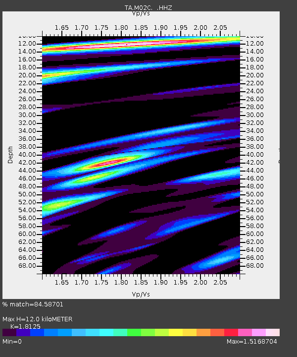
| Estimated Moho Depth: |
12.0 km |
| Estimated Crust Vp/Vs: |
1.81 |
| Assumed Crust Vp: |
6.566 km/s |
| Estimated Crust Vs: |
3.623 km/s |
| Estimated Crust Poisson's Ratio: |
0.28 |
|
| Radial Match: |
84.58701 % |
| Radial Bump: |
400 |
| Transverse Match: |
74.9633 % |
| Transverse Bump: |
400 |
| SOD ConfigId: |
769524 |
| Insert Time: |
2014-09-06 23:10:18.444 +0000 |
| GWidth: |
2.5 |
| Max Bumps: |
400 |
| Tol: |
0.001 |
|

Signal To Noise
| Channel | StoN | STA | LTA |
| TA:M02C: :HHZ:20140823T22:44:37.259993Z | 4.5988846 | 8.9792877E-7 | 1.9524926E-7 |
| TA:M02C: :HHN:20140823T22:44:37.259993Z | 1.3677733 | 1.3910565E-7 | 1.0170228E-7 |
| TA:M02C: :HHE:20140823T22:44:37.259993Z | 1.9279271 | 4.2158595E-7 | 2.1867316E-7 |
| Arrivals |
| Ps | 1.5 SECOND |
| PpPs | 5.0 SECOND |
| PsPs/PpSs | 6.5 SECOND |


