You are here: Home > Network List > TA - USArray Transportable Network (new EarthScope stations) Stations List
> Station M59A Waymart, PA, USA > Earthquake Result Viewer
M59A Waymart, PA, USA - Earthquake Result Viewer
| Earthquake location: |
Near Coast Of Central Chile |
| Earthquake latitude/longitude: |
-32.7/-71.4 |
| Earthquake time(UTC): |
2014/08/23 (235) 22:32:23 GMT |
| Earthquake Depth: |
32 km |
| Earthquake Magnitude: |
6.4 MWW, 6.6 MWP |
| Earthquake Catalog/Contributor: |
NEIC PDE/NEIC COMCAT |
|
| Network: |
TA USArray Transportable Network (new EarthScope stations) |
| Station: |
M59A Waymart, PA, USA |
| Lat/Lon: |
41.54 N/75.43 W |
| Elevation: |
471 m |
|
| Distance: |
74.0 deg |
| Az: |
356.842 deg |
| Baz: |
176.452 deg |
| Ray Param: |
0.052601207 |
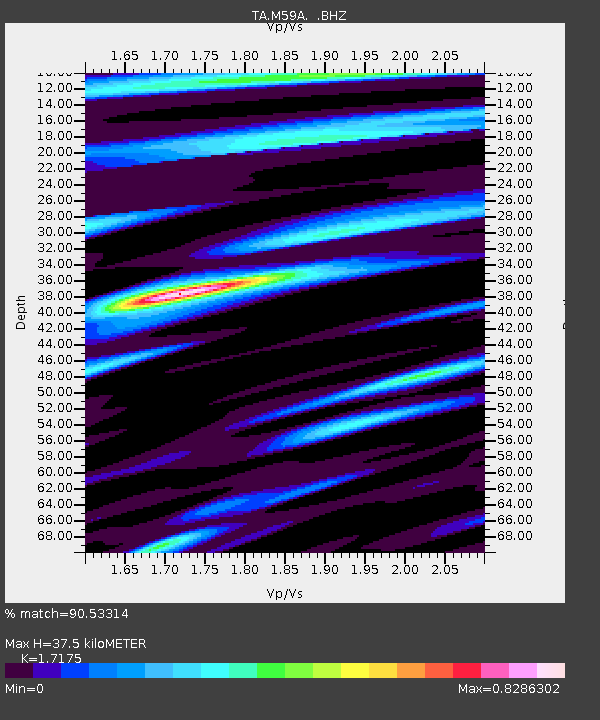
| Estimated Moho Depth: |
37.5 km |
| Estimated Crust Vp/Vs: |
1.72 |
| Assumed Crust Vp: |
6.283 km/s |
| Estimated Crust Vs: |
3.658 km/s |
| Estimated Crust Poisson's Ratio: |
0.24 |
|
| Radial Match: |
90.53314 % |
| Radial Bump: |
400 |
| Transverse Match: |
75.98592 % |
| Transverse Bump: |
400 |
| SOD ConfigId: |
769524 |
| Insert Time: |
2014-09-06 23:10:40.567 +0000 |
| GWidth: |
2.5 |
| Max Bumps: |
400 |
| Tol: |
0.001 |
|
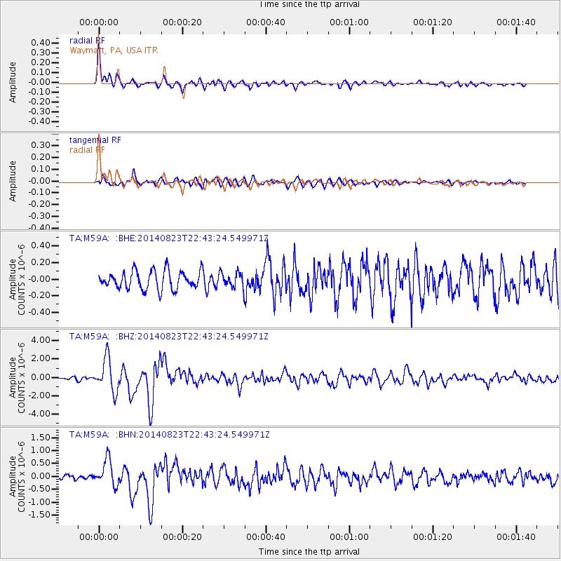
Signal To Noise
| Channel | StoN | STA | LTA |
| TA:M59A: :BHZ:20140823T22:43:24.549971Z | 12.180045 | 1.8482727E-6 | 1.5174597E-7 |
| TA:M59A: :BHN:20140823T22:43:24.549971Z | 6.694624 | 5.261396E-7 | 7.859136E-8 |
| TA:M59A: :BHE:20140823T22:43:24.549971Z | 0.8659044 | 9.4535636E-8 | 1.091756E-7 |
| Arrivals |
| Ps | 4.4 SECOND |
| PpPs | 16 SECOND |
| PsPs/PpSs | 20 SECOND |


