You are here: Home > Network List > TA - USArray Transportable Network (new EarthScope stations) Stations List
> Station M63A Gales Ferry, CT, USA > Earthquake Result Viewer
M63A Gales Ferry, CT, USA - Earthquake Result Viewer
| Earthquake location: |
Near Coast Of Central Chile |
| Earthquake latitude/longitude: |
-32.7/-71.4 |
| Earthquake time(UTC): |
2014/08/23 (235) 22:32:23 GMT |
| Earthquake Depth: |
32 km |
| Earthquake Magnitude: |
6.4 MWW, 6.6 MWP |
| Earthquake Catalog/Contributor: |
NEIC PDE/NEIC COMCAT |
|
| Network: |
TA USArray Transportable Network (new EarthScope stations) |
| Station: |
M63A Gales Ferry, CT, USA |
| Lat/Lon: |
41.40 N/72.05 W |
| Elevation: |
44 m |
|
| Distance: |
73.7 deg |
| Az: |
359.483 deg |
| Baz: |
179.421 deg |
| Ray Param: |
0.052754942 |
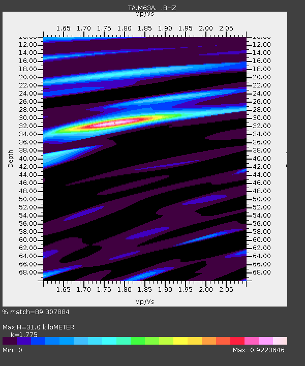
| Estimated Moho Depth: |
31.0 km |
| Estimated Crust Vp/Vs: |
1.77 |
| Assumed Crust Vp: |
6.472 km/s |
| Estimated Crust Vs: |
3.646 km/s |
| Estimated Crust Poisson's Ratio: |
0.27 |
|
| Radial Match: |
89.307884 % |
| Radial Bump: |
353 |
| Transverse Match: |
65.08364 % |
| Transverse Bump: |
400 |
| SOD ConfigId: |
769524 |
| Insert Time: |
2014-09-06 23:10:49.101 +0000 |
| GWidth: |
2.5 |
| Max Bumps: |
400 |
| Tol: |
0.001 |
|

Signal To Noise
| Channel | StoN | STA | LTA |
| TA:M63A: :BHZ:20140823T22:43:23.22502Z | 7.7040896 | 1.4418425E-6 | 1.8715288E-7 |
| TA:M63A: :BHN:20140823T22:43:23.22502Z | 4.0453825 | 5.384248E-7 | 1.3309614E-7 |
| TA:M63A: :BHE:20140823T22:43:23.22502Z | 1.5577332 | 1.7415532E-7 | 1.1180048E-7 |
| Arrivals |
| Ps | 3.8 SECOND |
| PpPs | 13 SECOND |
| PsPs/PpSs | 17 SECOND |


