You are here: Home > Network List > TA - USArray Transportable Network (new EarthScope stations) Stations List
> Station MDND Maddock, ND, USA > Earthquake Result Viewer
MDND Maddock, ND, USA - Earthquake Result Viewer
| Earthquake location: |
Near Coast Of Central Chile |
| Earthquake latitude/longitude: |
-32.7/-71.4 |
| Earthquake time(UTC): |
2014/08/23 (235) 22:32:23 GMT |
| Earthquake Depth: |
32 km |
| Earthquake Magnitude: |
6.4 MWW, 6.6 MWP |
| Earthquake Catalog/Contributor: |
NEIC PDE/NEIC COMCAT |
|
| Network: |
TA USArray Transportable Network (new EarthScope stations) |
| Station: |
MDND Maddock, ND, USA |
| Lat/Lon: |
47.85 N/99.60 W |
| Elevation: |
479 m |
|
| Distance: |
84.1 deg |
| Az: |
341.327 deg |
| Baz: |
156.374 deg |
| Ray Param: |
0.045687735 |
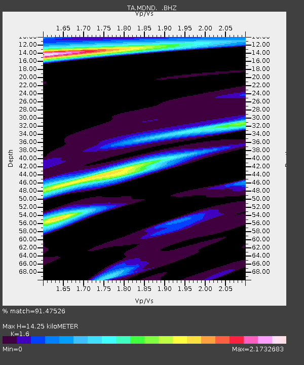
| Estimated Moho Depth: |
14.25 km |
| Estimated Crust Vp/Vs: |
1.60 |
| Assumed Crust Vp: |
6.53 km/s |
| Estimated Crust Vs: |
4.082 km/s |
| Estimated Crust Poisson's Ratio: |
0.18 |
|
| Radial Match: |
91.47526 % |
| Radial Bump: |
400 |
| Transverse Match: |
76.460754 % |
| Transverse Bump: |
400 |
| SOD ConfigId: |
769524 |
| Insert Time: |
2014-09-06 23:10:54.981 +0000 |
| GWidth: |
2.5 |
| Max Bumps: |
400 |
| Tol: |
0.001 |
|
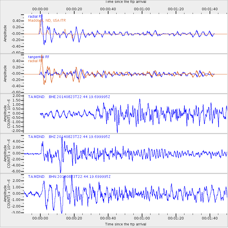
Signal To Noise
| Channel | StoN | STA | LTA |
| TA:MDND: :BHZ:20140823T22:44:19.699995Z | 17.075212 | 1.5975368E-6 | 9.355882E-8 |
| TA:MDND: :BHN:20140823T22:44:19.699995Z | 4.743269 | 1.1636836E-6 | 2.453337E-7 |
| TA:MDND: :BHE:20140823T22:44:19.699995Z | 1.7227019 | 3.9180404E-7 | 2.2743578E-7 |
| Arrivals |
| Ps | 1.3 SECOND |
| PpPs | 5.5 SECOND |
| PsPs/PpSs | 6.9 SECOND |


