You are here: Home > Network List > TA - USArray Transportable Network (new EarthScope stations) Stations List
> Station P53A Whipple, OH, USA > Earthquake Result Viewer
P53A Whipple, OH, USA - Earthquake Result Viewer
| Earthquake location: |
Near Coast Of Central Chile |
| Earthquake latitude/longitude: |
-32.7/-71.4 |
| Earthquake time(UTC): |
2014/08/23 (235) 22:32:23 GMT |
| Earthquake Depth: |
32 km |
| Earthquake Magnitude: |
6.4 MWW, 6.6 MWP |
| Earthquake Catalog/Contributor: |
NEIC PDE/NEIC COMCAT |
|
| Network: |
TA USArray Transportable Network (new EarthScope stations) |
| Station: |
P53A Whipple, OH, USA |
| Lat/Lon: |
39.49 N/81.39 W |
| Elevation: |
270 m |
|
| Distance: |
72.4 deg |
| Az: |
351.894 deg |
| Baz: |
171.163 deg |
| Ray Param: |
0.053624555 |
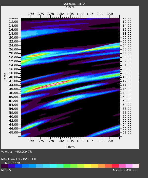
| Estimated Moho Depth: |
43.0 km |
| Estimated Crust Vp/Vs: |
1.78 |
| Assumed Crust Vp: |
6.207 km/s |
| Estimated Crust Vs: |
3.492 km/s |
| Estimated Crust Poisson's Ratio: |
0.27 |
|
| Radial Match: |
92.23475 % |
| Radial Bump: |
400 |
| Transverse Match: |
87.365944 % |
| Transverse Bump: |
400 |
| SOD ConfigId: |
769524 |
| Insert Time: |
2014-09-06 23:12:06.075 +0000 |
| GWidth: |
2.5 |
| Max Bumps: |
400 |
| Tol: |
0.001 |
|
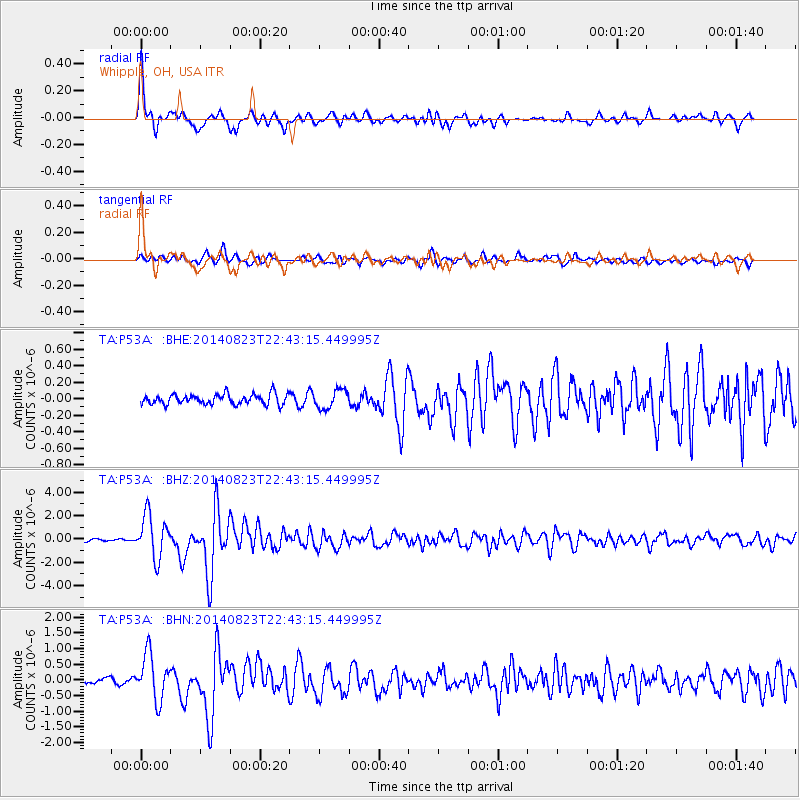
Signal To Noise
| Channel | StoN | STA | LTA |
| TA:P53A: :BHZ:20140823T22:43:15.449995Z | 19.966446 | 1.8300958E-6 | 9.165856E-8 |
| TA:P53A: :BHN:20140823T22:43:15.449995Z | 7.2939844 | 7.233552E-7 | 9.917148E-8 |
| TA:P53A: :BHE:20140823T22:43:15.449995Z | 1.851196 | 1.1463775E-7 | 6.1926315E-8 |
| Arrivals |
| Ps | 5.6 SECOND |
| PpPs | 19 SECOND |
| PsPs/PpSs | 24 SECOND |


