You are here: Home > Network List > TA - USArray Transportable Network (new EarthScope stations) Stations List
> Station P60A Greenville, DE, USA > Earthquake Result Viewer
P60A Greenville, DE, USA - Earthquake Result Viewer
| Earthquake location: |
Near Coast Of Central Chile |
| Earthquake latitude/longitude: |
-32.7/-71.4 |
| Earthquake time(UTC): |
2014/08/23 (235) 22:32:23 GMT |
| Earthquake Depth: |
32 km |
| Earthquake Magnitude: |
6.4 MWW, 6.6 MWP |
| Earthquake Catalog/Contributor: |
NEIC PDE/NEIC COMCAT |
|
| Network: |
TA USArray Transportable Network (new EarthScope stations) |
| Station: |
P60A Greenville, DE, USA |
| Lat/Lon: |
39.81 N/75.64 W |
| Elevation: |
105 m |
|
| Distance: |
72.3 deg |
| Az: |
356.565 deg |
| Baz: |
176.239 deg |
| Ray Param: |
0.053734295 |
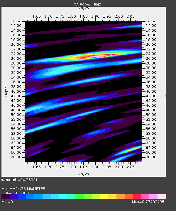
| Estimated Moho Depth: |
24.75 km |
| Estimated Crust Vp/Vs: |
1.91 |
| Assumed Crust Vp: |
6.287 km/s |
| Estimated Crust Vs: |
3.292 km/s |
| Estimated Crust Poisson's Ratio: |
0.31 |
|
| Radial Match: |
94.75831 % |
| Radial Bump: |
400 |
| Transverse Match: |
84.17007 % |
| Transverse Bump: |
400 |
| SOD ConfigId: |
769524 |
| Insert Time: |
2014-09-06 23:12:20.309 +0000 |
| GWidth: |
2.5 |
| Max Bumps: |
400 |
| Tol: |
0.001 |
|
Signal To Noise
| Channel | StoN | STA | LTA |
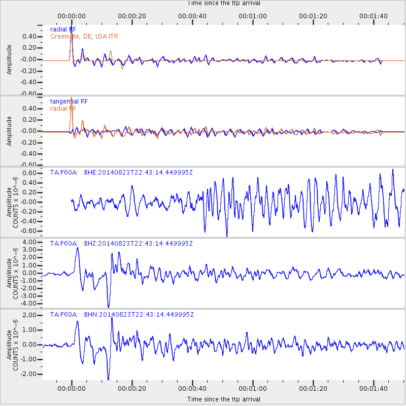
| TA:P60A: :BHZ:20140823T22:43:14.449995Z | 11.116845 | 1.5736757E-6 | 1.4155776E-7 |
| TA:P60A: :BHN:20140823T22:43:14.449995Z | 10.7798 | 8.0699346E-7 | 7.486163E-8 |
| TA:P60A: :BHE:20140823T22:43:14.449995Z | 0.7832659 | 9.150055E-8 | 1.1681928E-7 |
| Arrivals |
| Ps | 3.7 SECOND |
| PpPs | 11 SECOND |
| PsPs/PpSs | 15 SECOND |


