You are here: Home > Network List > AV - Alaska Volcano Observatory Stations List
> Station AMKA Regional Station, Amchitka Island, Alaska > Earthquake Result Viewer
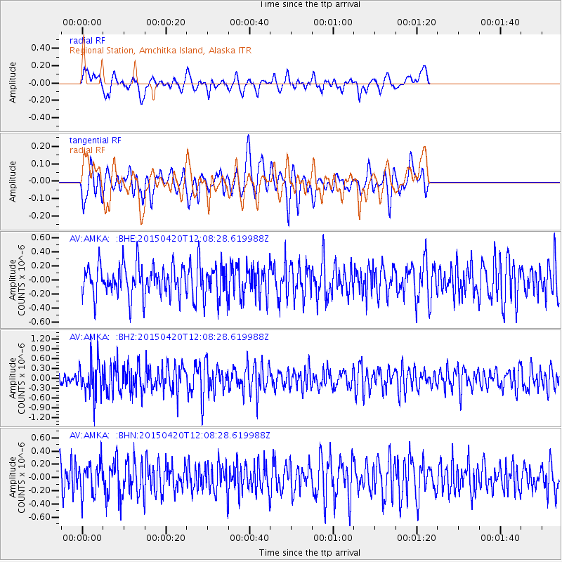
AMKA Regional Station, Amchitka Island, Alaska - Earthquake Result Viewer
*The percent match for this event was below the threshold and hence no stack was calculated.
| Earthquake location: |
Taiwan Region |
| Earthquake latitude/longitude: |
24.1/122.5 |
| Earthquake time(UTC): |
2015/04/20 (110) 11:59:59 GMT |
| Earthquake Depth: |
20 km |
| Earthquake Magnitude: |
6.1 MWW |
| Earthquake Catalog/Contributor: |
NEIC PDE/NEIC COMCAT |
|
| Network: |
AV Alaska Volcano Observatory |
| Station: |
AMKA Regional Station, Amchitka Island, Alaska |
| Lat/Lon: |
51.38 N/179.30 E |
| Elevation: |
116 m |
|
| Distance: |
51.0 deg |
| Az: |
42.471 deg |
| Baz: |
259.948 deg |
| Ray Param: |
$rayparam |
*The percent match for this event was below the threshold and hence was not used in the summary stack. |
|
| Radial Match: |
47.92773 % |
| Radial Bump: |
400 |
| Transverse Match: |
60.617588 % |
| Transverse Bump: |
400 |
| SOD ConfigId: |
7422571 |
| Insert Time: |
2019-04-18 06:47:29.617 +0000 |
| GWidth: |
2.5 |
| Max Bumps: |
400 |
| Tol: |
0.001 |
|
Signal To Noise
| Channel | StoN | STA | LTA |
| AV:AMKA: :BHZ:20150420T12:08:28.619988Z | 2.6408174 | 5.3024485E-7 | 2.0078815E-7 |
| AV:AMKA: :BHN:20150420T12:08:28.619988Z | 1.2794874 | 2.3655272E-7 | 1.8488086E-7 |
| AV:AMKA: :BHE:20150420T12:08:28.619988Z | 1.0500177 | 2.2112968E-7 | 2.1059613E-7 |
| Arrivals |
| Ps | |
| PpPs | |
| PsPs/PpSs | |


