You are here: Home > Network List > CN - Canadian National Seismograph Network Stations List
> Station INK INUVIK, NT > Earthquake Result Viewer
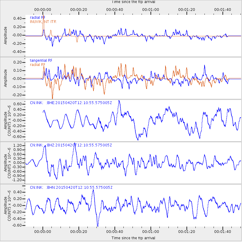
INK INUVIK, NT - Earthquake Result Viewer
*The percent match for this event was below the threshold and hence no stack was calculated.
| Earthquake location: |
Taiwan Region |
| Earthquake latitude/longitude: |
24.1/122.5 |
| Earthquake time(UTC): |
2015/04/20 (110) 11:59:59 GMT |
| Earthquake Depth: |
20 km |
| Earthquake Magnitude: |
6.1 MWW |
| Earthquake Catalog/Contributor: |
NEIC PDE/NEIC COMCAT |
|
| Network: |
CN Canadian National Seismograph Network |
| Station: |
INK INUVIK, NT |
| Lat/Lon: |
68.31 N/133.53 W |
| Elevation: |
44 m |
|
| Distance: |
72.9 deg |
| Az: |
22.182 deg |
| Baz: |
291.86 deg |
| Ray Param: |
$rayparam |
*The percent match for this event was below the threshold and hence was not used in the summary stack. |
|
| Radial Match: |
74.33947 % |
| Radial Bump: |
400 |
| Transverse Match: |
66.763306 % |
| Transverse Bump: |
400 |
| SOD ConfigId: |
7422571 |
| Insert Time: |
2019-04-18 06:48:03.135 +0000 |
| GWidth: |
2.5 |
| Max Bumps: |
400 |
| Tol: |
0.001 |
|
Signal To Noise
| Channel | StoN | STA | LTA |
| CN:INK: :BHZ:20150420T12:10:55.575005Z | 5.981888 | 7.1570855E-7 | 1.1964593E-7 |
| CN:INK: :BHN:20150420T12:10:55.575005Z | 1.1994177 | 1.5598545E-7 | 1.3005098E-7 |
| CN:INK: :BHE:20150420T12:10:55.575005Z | 1.1216878 | 2.197756E-7 | 1.9593296E-7 |
| Arrivals |
| Ps | |
| PpPs | |
| PsPs/PpSs | |


