You are here: Home > Network List > TA - USArray Transportable Network (new EarthScope stations) Stations List
> Station T54A Tazewell, VA, USA > Earthquake Result Viewer
T54A Tazewell, VA, USA - Earthquake Result Viewer
| Earthquake location: |
Near Coast Of Central Chile |
| Earthquake latitude/longitude: |
-32.7/-71.4 |
| Earthquake time(UTC): |
2014/08/23 (235) 22:32:23 GMT |
| Earthquake Depth: |
32 km |
| Earthquake Magnitude: |
6.4 MWW, 6.6 MWP |
| Earthquake Catalog/Contributor: |
NEIC PDE/NEIC COMCAT |
|
| Network: |
TA USArray Transportable Network (new EarthScope stations) |
| Station: |
T54A Tazewell, VA, USA |
| Lat/Lon: |
37.06 N/81.58 W |
| Elevation: |
852 m |
|
| Distance: |
70.1 deg |
| Az: |
351.342 deg |
| Baz: |
170.87 deg |
| Ray Param: |
0.055190653 |
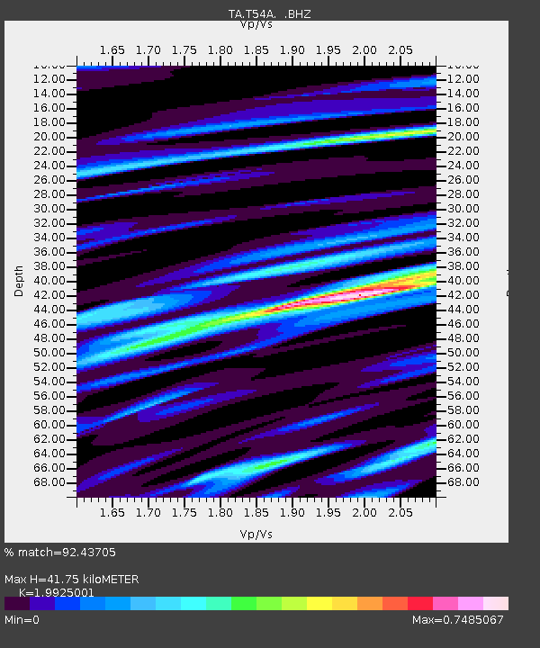
| Estimated Moho Depth: |
41.75 km |
| Estimated Crust Vp/Vs: |
1.99 |
| Assumed Crust Vp: |
6.159 km/s |
| Estimated Crust Vs: |
3.091 km/s |
| Estimated Crust Poisson's Ratio: |
0.33 |
|
| Radial Match: |
92.43705 % |
| Radial Bump: |
400 |
| Transverse Match: |
85.60245 % |
| Transverse Bump: |
400 |
| SOD ConfigId: |
769524 |
| Insert Time: |
2014-09-06 23:14:02.168 +0000 |
| GWidth: |
2.5 |
| Max Bumps: |
400 |
| Tol: |
0.001 |
|
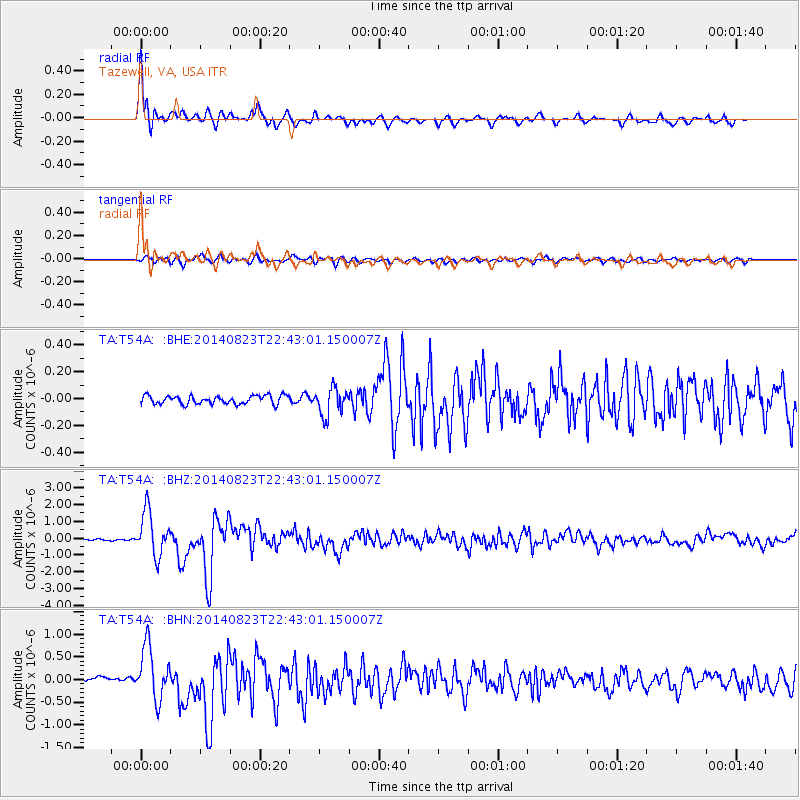
Signal To Noise
| Channel | StoN | STA | LTA |
| TA:T54A: :BHZ:20140823T22:43:01.150007Z | 30.560564 | 1.3052032E-6 | 4.270874E-8 |
| TA:T54A: :BHN:20140823T22:43:01.150007Z | 11.082848 | 5.621689E-7 | 5.0724232E-8 |
| TA:T54A: :BHE:20140823T22:43:01.150007Z | 3.1859756 | 1.0002094E-7 | 3.1394134E-8 |
| Arrivals |
| Ps | 6.9 SECOND |
| PpPs | 20 SECOND |
| PsPs/PpSs | 27 SECOND |


