You are here: Home > Network List > TA - USArray Transportable Network (new EarthScope stations) Stations List
> Station V60A Jim Taylor Road, Stokes, NC, USA > Earthquake Result Viewer
V60A Jim Taylor Road, Stokes, NC, USA - Earthquake Result Viewer
| Earthquake location: |
Near Coast Of Central Chile |
| Earthquake latitude/longitude: |
-32.7/-71.4 |
| Earthquake time(UTC): |
2014/08/23 (235) 22:32:23 GMT |
| Earthquake Depth: |
32 km |
| Earthquake Magnitude: |
6.4 MWW, 6.6 MWP |
| Earthquake Catalog/Contributor: |
NEIC PDE/NEIC COMCAT |
|
| Network: |
TA USArray Transportable Network (new EarthScope stations) |
| Station: |
V60A Jim Taylor Road, Stokes, NC, USA |
| Lat/Lon: |
35.76 N/77.26 W |
| Elevation: |
8.0 m |
|
| Distance: |
68.3 deg |
| Az: |
354.86 deg |
| Baz: |
174.671 deg |
| Ray Param: |
0.056324817 |
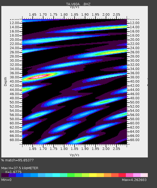
| Estimated Moho Depth: |
37.5 km |
| Estimated Crust Vp/Vs: |
1.68 |
| Assumed Crust Vp: |
6.565 km/s |
| Estimated Crust Vs: |
3.913 km/s |
| Estimated Crust Poisson's Ratio: |
0.22 |
|
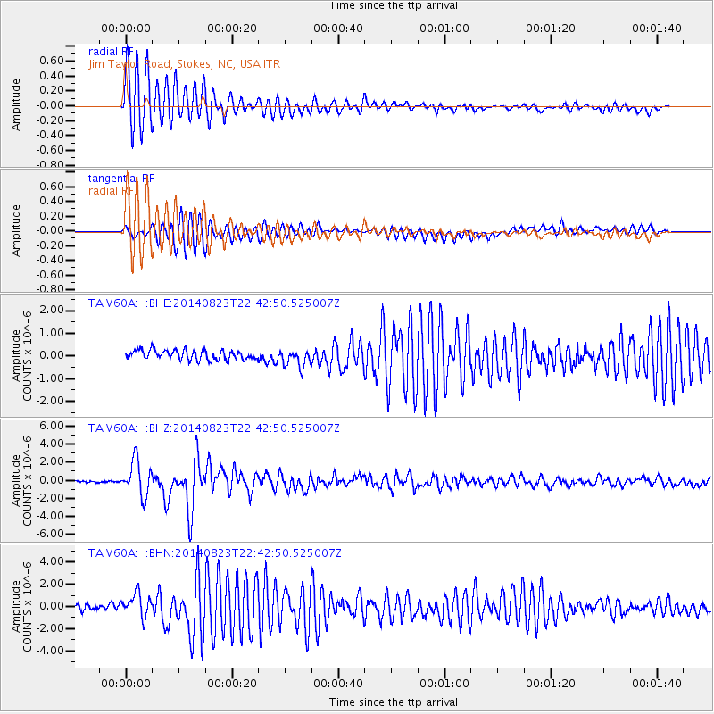
| Radial Match: |
95.65377 % |
| Radial Bump: |
400 |
| Transverse Match: |
89.24807 % |
| Transverse Bump: |
400 |
| SOD ConfigId: |
769524 |
| Insert Time: |
2014-09-06 23:14:56.980 +0000 |
| GWidth: |
2.5 |
| Max Bumps: |
400 |
| Tol: |
0.001 |
|
Signal To Noise
| Channel | StoN | STA | LTA |
| TA:V60A: :BHZ:20140823T22:42:50.525007Z | 28.02335 | 1.972896E-6 | 7.040186E-8 |
| TA:V60A: :BHN:20140823T22:42:50.525007Z | 4.9126215 | 1.0903009E-6 | 2.219387E-7 |
| TA:V60A: :BHE:20140823T22:42:50.525007Z | 1.925731 | 4.0157175E-7 | 2.0852953E-7 |
| Arrivals |
| Ps | 4.0 SECOND |
| PpPs | 15 SECOND |
| PsPs/PpSs | 19 SECOND |


