You are here: Home > Network List > TA - USArray Transportable Network (new EarthScope stations) Stations List
> Station X60A Albert Glenn Thornton, NC, USA > Earthquake Result Viewer
X60A Albert Glenn Thornton, NC, USA - Earthquake Result Viewer
| Earthquake location: |
Near Coast Of Central Chile |
| Earthquake latitude/longitude: |
-32.7/-71.4 |
| Earthquake time(UTC): |
2014/08/23 (235) 22:32:23 GMT |
| Earthquake Depth: |
32 km |
| Earthquake Magnitude: |
6.4 MWW, 6.6 MWP |
| Earthquake Catalog/Contributor: |
NEIC PDE/NEIC COMCAT |
|
| Network: |
TA USArray Transportable Network (new EarthScope stations) |
| Station: |
X60A Albert Glenn Thornton, NC, USA |
| Lat/Lon: |
34.58 N/77.98 W |
| Elevation: |
12 m |
|
| Distance: |
67.2 deg |
| Az: |
354.105 deg |
| Baz: |
173.976 deg |
| Ray Param: |
0.057055704 |
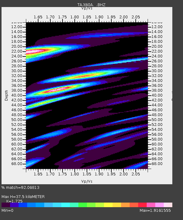
| Estimated Moho Depth: |
37.5 km |
| Estimated Crust Vp/Vs: |
1.73 |
| Assumed Crust Vp: |
6.565 km/s |
| Estimated Crust Vs: |
3.806 km/s |
| Estimated Crust Poisson's Ratio: |
0.25 |
|
| Radial Match: |
92.06813 % |
| Radial Bump: |
400 |
| Transverse Match: |
77.49796 % |
| Transverse Bump: |
400 |
| SOD ConfigId: |
769524 |
| Insert Time: |
2014-09-06 23:15:45.236 +0000 |
| GWidth: |
2.5 |
| Max Bumps: |
400 |
| Tol: |
0.001 |
|
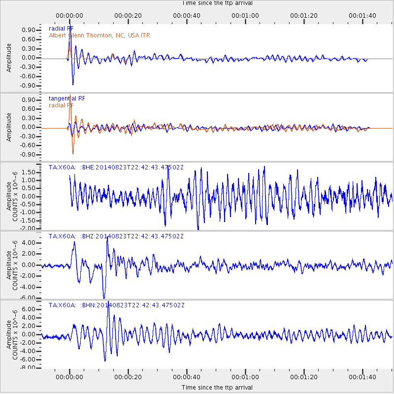
Signal To Noise
| Channel | StoN | STA | LTA |
| TA:X60A: :BHZ:20140823T22:42:43.47502Z | 10.181731 | 2.028687E-6 | 1.9924775E-7 |
| TA:X60A: :BHN:20140823T22:42:43.47502Z | 2.338331 | 1.64486E-6 | 7.034334E-7 |
| TA:X60A: :BHE:20140823T22:42:43.47502Z | 2.1450758 | 8.674738E-7 | 4.0440239E-7 |
| Arrivals |
| Ps | 4.3 SECOND |
| PpPs | 15 SECOND |
| PsPs/PpSs | 19 SECOND |


