You are here: Home > Network List > TA - USArray Transportable Network (new EarthScope stations) Stations List
> Station Z41A Richland Creek Farm, El Dorado, AR, USA > Earthquake Result Viewer
Z41A Richland Creek Farm, El Dorado, AR, USA - Earthquake Result Viewer
| Earthquake location: |
Near Coast Of Central Chile |
| Earthquake latitude/longitude: |
-32.7/-71.4 |
| Earthquake time(UTC): |
2014/08/23 (235) 22:32:23 GMT |
| Earthquake Depth: |
32 km |
| Earthquake Magnitude: |
6.4 MWW, 6.6 MWP |
| Earthquake Catalog/Contributor: |
NEIC PDE/NEIC COMCAT |
|
| Network: |
TA USArray Transportable Network (new EarthScope stations) |
| Station: |
Z41A Richland Creek Farm, El Dorado, AR, USA |
| Lat/Lon: |
33.26 N/92.80 W |
| Elevation: |
62 m |
|
| Distance: |
68.6 deg |
| Az: |
340.822 deg |
| Baz: |
160.697 deg |
| Ray Param: |
0.056122076 |
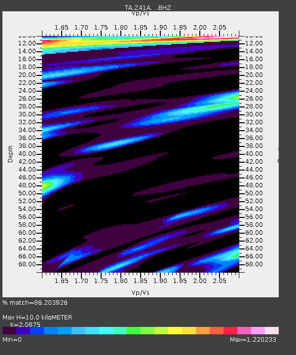
| Estimated Moho Depth: |
10.0 km |
| Estimated Crust Vp/Vs: |
2.10 |
| Assumed Crust Vp: |
6.245 km/s |
| Estimated Crust Vs: |
2.977 km/s |
| Estimated Crust Poisson's Ratio: |
0.35 |
|
| Radial Match: |
86.203926 % |
| Radial Bump: |
377 |
| Transverse Match: |
79.72836 % |
| Transverse Bump: |
394 |
| SOD ConfigId: |
769524 |
| Insert Time: |
2014-09-06 23:15:59.159 +0000 |
| GWidth: |
2.5 |
| Max Bumps: |
400 |
| Tol: |
0.001 |
|

Signal To Noise
| Channel | StoN | STA | LTA |
| TA:Z41A: :BHZ:20140823T22:42:52.449995Z | 16.37661 | 2.2186475E-6 | 1.3547661E-7 |
| TA:Z41A: :BHN:20140823T22:42:52.449995Z | 3.2163064 | 7.93222E-7 | 2.4662512E-7 |
| TA:Z41A: :BHE:20140823T22:42:52.449995Z | 3.1471837 | 4.327677E-7 | 1.3750952E-7 |
| Arrivals |
| Ps | 1.8 SECOND |
| PpPs | 4.8 SECOND |
| PsPs/PpSs | 6.6 SECOND |


