You are here: Home > Network List > TA - USArray Transportable Network (new EarthScope stations) Stations List
> Station Z59A Georgetown, SC, USA > Earthquake Result Viewer
Z59A Georgetown, SC, USA - Earthquake Result Viewer
| Earthquake location: |
Near Coast Of Central Chile |
| Earthquake latitude/longitude: |
-32.7/-71.4 |
| Earthquake time(UTC): |
2014/08/23 (235) 22:32:23 GMT |
| Earthquake Depth: |
32 km |
| Earthquake Magnitude: |
6.4 MWW, 6.6 MWP |
| Earthquake Catalog/Contributor: |
NEIC PDE/NEIC COMCAT |
|
| Network: |
TA USArray Transportable Network (new EarthScope stations) |
| Station: |
Z59A Georgetown, SC, USA |
| Lat/Lon: |
33.24 N/79.28 W |
| Elevation: |
8.0 m |
|
| Distance: |
66.0 deg |
| Az: |
352.765 deg |
| Baz: |
172.721 deg |
| Ray Param: |
0.05784488 |
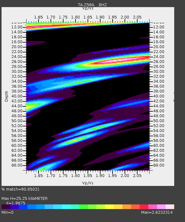
| Estimated Moho Depth: |
25.25 km |
| Estimated Crust Vp/Vs: |
1.97 |
| Assumed Crust Vp: |
6.24 km/s |
| Estimated Crust Vs: |
3.172 km/s |
| Estimated Crust Poisson's Ratio: |
0.33 |
|
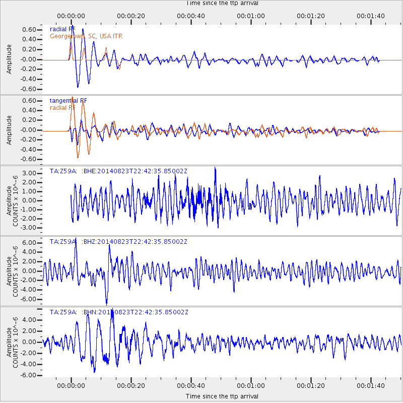
| Radial Match: |
90.85021 % |
| Radial Bump: |
390 |
| Transverse Match: |
74.388054 % |
| Transverse Bump: |
400 |
| SOD ConfigId: |
769524 |
| Insert Time: |
2014-09-06 23:16:08.451 +0000 |
| GWidth: |
2.5 |
| Max Bumps: |
400 |
| Tol: |
0.001 |
|
Signal To Noise
| Channel | StoN | STA | LTA |
| TA:Z59A: :BHZ:20140823T22:42:35.85002Z | 1.6345106 | 2.3974183E-6 | 1.4667498E-6 |
| TA:Z59A: :BHN:20140823T22:42:35.85002Z | 2.6196203 | 2.0626387E-6 | 7.8738077E-7 |
| TA:Z59A: :BHE:20140823T22:42:35.85002Z | 1.4751344 | 1.5684315E-6 | 1.0632465E-6 |
| Arrivals |
| Ps | 4.1 SECOND |
| PpPs | 12 SECOND |
| PsPs/PpSs | 16 SECOND |


