You are here: Home > Network List > II - Global Seismograph Network (GSN - IRIS/IDA) Stations List
> Station ALE Alert, N.W.T., Canada > Earthquake Result Viewer
ALE Alert, N.W.T., Canada - Earthquake Result Viewer
| Earthquake location: |
Near Coast Of Nicaragua |
| Earthquake latitude/longitude: |
11.4/-86.7 |
| Earthquake time(UTC): |
2004/10/09 (283) 21:26:53 GMT |
| Earthquake Depth: |
35 km |
| Earthquake Magnitude: |
6.0 MB, 7.0 MS, 6.9 MW, 6.8 MW |
| Earthquake Catalog/Contributor: |
WHDF/NEIC |
|
| Network: |
II Global Seismograph Network (GSN - IRIS/IDA) |
| Station: |
ALE Alert, N.W.T., Canada |
| Lat/Lon: |
82.50 N/62.35 W |
| Elevation: |
60 m |
|
| Distance: |
71.8 deg |
| Az: |
3.263 deg |
| Baz: |
205.149 deg |
| Ray Param: |
0.054034833 |
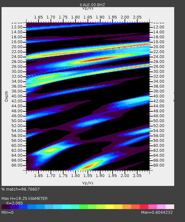
| Estimated Moho Depth: |
19.25 km |
| Estimated Crust Vp/Vs: |
2.07 |
| Assumed Crust Vp: |
6.287 km/s |
| Estimated Crust Vs: |
3.045 km/s |
| Estimated Crust Poisson's Ratio: |
0.35 |
|
| Radial Match: |
96.78607 % |
| Radial Bump: |
362 |
| Transverse Match: |
78.44171 % |
| Transverse Bump: |
400 |
| SOD ConfigId: |
2459 |
| Insert Time: |
2010-03-02 01:02:03.635 +0000 |
| GWidth: |
2.5 |
| Max Bumps: |
400 |
| Tol: |
0.001 |
|

Signal To Noise
| Channel | StoN | STA | LTA |
| II:ALE:00:BHN:20041009T21:37:41.749021Z | 7.652008 | 1.6703679E-6 | 2.1829143E-7 |
| II:ALE:00:BHE:20041009T21:37:41.749021Z | 4.4257107 | 6.890362E-7 | 1.5568938E-7 |
| II:ALE:00:BHZ:20041009T21:37:41.749021Z | 14.331928 | 3.831404E-6 | 2.6733343E-7 |
| Arrivals |
| Ps | 3.4 SECOND |
| PpPs | 9.1 SECOND |
| PsPs/PpSs | 12 SECOND |


