You are here: Home > Network List > UU - University of Utah Regional Network Stations List
> Station ASI2 Darling Creek, Challis, ID, USA > Earthquake Result Viewer
ASI2 Darling Creek, Challis, ID, USA - Earthquake Result Viewer
| Earthquake location: |
Near Coast Of Central Chile |
| Earthquake latitude/longitude: |
-32.7/-71.4 |
| Earthquake time(UTC): |
2014/08/23 (235) 22:32:23 GMT |
| Earthquake Depth: |
32 km |
| Earthquake Magnitude: |
6.4 MWW, 6.6 MWP |
| Earthquake Catalog/Contributor: |
NEIC PDE/NEIC COMCAT |
|
| Network: |
UU University of Utah Regional Network |
| Station: |
ASI2 Darling Creek, Challis, ID, USA |
| Lat/Lon: |
44.57 N/114.26 W |
| Elevation: |
1600 m |
|
| Distance: |
86.2 deg |
| Az: |
330.838 deg |
| Baz: |
144.91 deg |
| Ray Param: |
0.04415104 |
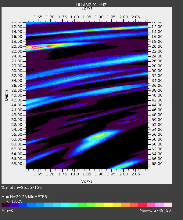
| Estimated Moho Depth: |
20.25 km |
| Estimated Crust Vp/Vs: |
1.62 |
| Assumed Crust Vp: |
6.577 km/s |
| Estimated Crust Vs: |
4.047 km/s |
| Estimated Crust Poisson's Ratio: |
0.20 |
|
| Radial Match: |
85.157135 % |
| Radial Bump: |
339 |
| Transverse Match: |
75.5617 % |
| Transverse Bump: |
390 |
| SOD ConfigId: |
769524 |
| Insert Time: |
2014-09-06 23:19:26.278 +0000 |
| GWidth: |
2.5 |
| Max Bumps: |
400 |
| Tol: |
0.001 |
|

Signal To Noise
| Channel | StoN | STA | LTA |
| UU:ASI2:01:HHZ:20140823T22:44:30.447981Z | 0.8468846 | 2.9175126E-8 | 3.4449943E-8 |
| UU:ASI2:01:HHN:20140823T22:44:30.447981Z | 0.5354138 | 3.761432E-8 | 7.02528E-8 |
| UU:ASI2:01:HHE:20140823T22:44:30.447981Z | 2.052609 | 2.9332291E-8 | 1.4290249E-8 |
| Arrivals |
| Ps | 2.0 SECOND |
| PpPs | 7.9 SECOND |
| PsPs/PpSs | 9.8 SECOND |


