You are here: Home > Network List > WY - Yellowstone Wyoming Seismic Network Stations List
> Station YTP The Promontory, YNP, WY, USA > Earthquake Result Viewer
YTP The Promontory, YNP, WY, USA - Earthquake Result Viewer
| Earthquake location: |
Near Coast Of Central Chile |
| Earthquake latitude/longitude: |
-32.7/-71.4 |
| Earthquake time(UTC): |
2014/08/23 (235) 22:32:23 GMT |
| Earthquake Depth: |
32 km |
| Earthquake Magnitude: |
6.4 MWW, 6.6 MWP |
| Earthquake Catalog/Contributor: |
NEIC PDE/NEIC COMCAT |
|
| Network: |
WY Yellowstone Wyoming Seismic Network |
| Station: |
YTP The Promontory, YNP, WY, USA |
| Lat/Lon: |
44.39 N/110.29 W |
| Elevation: |
2384 m |
|
| Distance: |
84.5 deg |
| Az: |
333.112 deg |
| Baz: |
147.868 deg |
| Ray Param: |
0.04538539 |
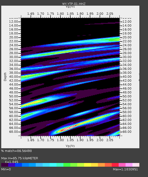
| Estimated Moho Depth: |
65.75 km |
| Estimated Crust Vp/Vs: |
1.85 |
| Assumed Crust Vp: |
6.35 km/s |
| Estimated Crust Vs: |
3.442 km/s |
| Estimated Crust Poisson's Ratio: |
0.29 |
|
| Radial Match: |
86.56498 % |
| Radial Bump: |
400 |
| Transverse Match: |
85.62053 % |
| Transverse Bump: |
400 |
| SOD ConfigId: |
769524 |
| Insert Time: |
2014-09-06 23:22:08.009 +0000 |
| GWidth: |
2.5 |
| Max Bumps: |
400 |
| Tol: |
0.001 |
|

Signal To Noise
| Channel | StoN | STA | LTA |
| WY:YTP:01:HHZ:20140823T22:44:21.868025Z | 11.798042 | 2.8568865E-8 | 2.421492E-9 |
| WY:YTP:01:HHN:20140823T22:44:21.868025Z | 3.8335326 | 1.2744458E-8 | 3.3244685E-9 |
| WY:YTP:01:HHE:20140823T22:44:21.868025Z | 3.4102786 | 1.0327427E-8 | 3.0283234E-9 |
| Arrivals |
| Ps | 9.0 SECOND |
| PpPs | 29 SECOND |
| PsPs/PpSs | 38 SECOND |


