You are here: Home > Network List > G - GEOSCOPE Stations List
> Station MPG Montagne des Peres, French Guyana > Earthquake Result Viewer
MPG Montagne des Peres, French Guyana - Earthquake Result Viewer
*The percent match for this event was below the threshold and hence no stack was calculated.
| Earthquake location: |
Northern California |
| Earthquake latitude/longitude: |
38.2/-122.3 |
| Earthquake time(UTC): |
2014/08/24 (236) 10:20:44 GMT |
| Earthquake Depth: |
7.8 km |
| Earthquake Magnitude: |
6.0 MW, 6.1 MI |
| Earthquake Catalog/Contributor: |
NEIC PDE/NEIC ALERT |
|
| Network: |
G GEOSCOPE |
| Station: |
MPG Montagne des Peres, French Guyana |
| Lat/Lon: |
5.11 N/52.64 W |
| Elevation: |
147 m |
|
| Distance: |
70.9 deg |
| Az: |
98.726 deg |
| Baz: |
308.581 deg |
| Ray Param: |
$rayparam |
*The percent match for this event was below the threshold and hence was not used in the summary stack. |
|
| Radial Match: |
74.856445 % |
| Radial Bump: |
400 |
| Transverse Match: |
55.169487 % |
| Transverse Bump: |
400 |
| SOD ConfigId: |
769524 |
| Insert Time: |
2014-09-07 10:40:52.699 +0000 |
| GWidth: |
2.5 |
| Max Bumps: |
400 |
| Tol: |
0.001 |
|
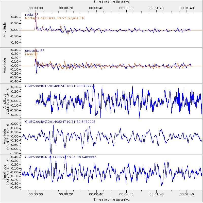
Signal To Noise
| Channel | StoN | STA | LTA |
| G:MPG:00:BHZ:20140824T10:31:30.648999Z | 2.6015096 | 2.3237628E-7 | 8.9323635E-8 |
| G:MPG:00:BHN:20140824T10:31:30.648999Z | 1.2681097 | 8.3635236E-8 | 6.595268E-8 |
| G:MPG:00:BHE:20140824T10:31:30.648999Z | 1.4022952 | 1.2467159E-7 | 8.8905374E-8 |
| Arrivals |
| Ps | |
| PpPs | |
| PsPs/PpSs | |


