You are here: Home > Network List > LD - Lamont-Doherty Cooperative Seismographic Network Stations List
> Station BRNY Black Rock Forest, Cornwall, NY > Earthquake Result Viewer
BRNY Black Rock Forest, Cornwall, NY - Earthquake Result Viewer
| Earthquake location: |
Northern California |
| Earthquake latitude/longitude: |
38.2/-122.3 |
| Earthquake time(UTC): |
2014/08/24 (236) 10:20:44 GMT |
| Earthquake Depth: |
7.8 km |
| Earthquake Magnitude: |
6.0 MW, 6.1 MI |
| Earthquake Catalog/Contributor: |
NEIC PDE/NEIC ALERT |
|
| Network: |
LD Lamont-Doherty Cooperative Seismographic Network |
| Station: |
BRNY Black Rock Forest, Cornwall, NY |
| Lat/Lon: |
41.41 N/74.01 W |
| Elevation: |
248 m |
|
| Distance: |
36.9 deg |
| Az: |
69.409 deg |
| Baz: |
281.344 deg |
| Ray Param: |
0.076450065 |
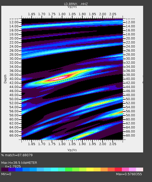
| Estimated Moho Depth: |
39.5 km |
| Estimated Crust Vp/Vs: |
1.78 |
| Assumed Crust Vp: |
6.283 km/s |
| Estimated Crust Vs: |
3.525 km/s |
| Estimated Crust Poisson's Ratio: |
0.27 |
|
| Radial Match: |
87.69079 % |
| Radial Bump: |
246 |
| Transverse Match: |
50.108055 % |
| Transverse Bump: |
400 |
| SOD ConfigId: |
769524 |
| Insert Time: |
2014-09-07 10:43:43.698 +0000 |
| GWidth: |
2.5 |
| Max Bumps: |
400 |
| Tol: |
0.001 |
|

Signal To Noise
| Channel | StoN | STA | LTA |
| LD:BRNY: :HHZ:20140824T10:27:22.319989Z | 2.4206555 | 3.565236E-7 | 1.4728391E-7 |
| LD:BRNY: :HHN:20140824T10:27:22.319989Z | 0.57738006 | 7.5321026E-8 | 1.304531E-7 |
| LD:BRNY: :HHE:20140824T10:27:22.319989Z | 1.5772334 | 1.8343785E-7 | 1.1630355E-7 |
| Arrivals |
| Ps | 5.3 SECOND |
| PpPs | 16 SECOND |
| PsPs/PpSs | 22 SECOND |


