You are here: Home > Network List > N4 - Central and EAstern US Network Stations List
> Station Z51A Franklin, GA, USA > Earthquake Result Viewer
Z51A Franklin, GA, USA - Earthquake Result Viewer
| Earthquake location: |
Northern California |
| Earthquake latitude/longitude: |
38.2/-122.3 |
| Earthquake time(UTC): |
2014/08/24 (236) 10:20:44 GMT |
| Earthquake Depth: |
7.8 km |
| Earthquake Magnitude: |
6.0 MW, 6.1 MI |
| Earthquake Catalog/Contributor: |
NEIC PDE/NEIC ALERT |
|
| Network: |
N4 Central and EAstern US Network |
| Station: |
Z51A Franklin, GA, USA |
| Lat/Lon: |
33.32 N/85.17 W |
| Elevation: |
249 m |
|
| Distance: |
30.4 deg |
| Az: |
87.783 deg |
| Baz: |
289.929 deg |
| Ray Param: |
0.079344705 |
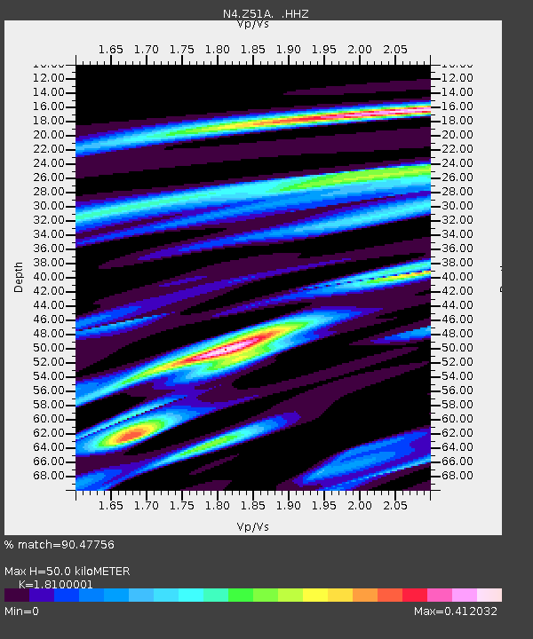
| Estimated Moho Depth: |
50.0 km |
| Estimated Crust Vp/Vs: |
1.81 |
| Assumed Crust Vp: |
6.719 km/s |
| Estimated Crust Vs: |
3.712 km/s |
| Estimated Crust Poisson's Ratio: |
0.28 |
|
| Radial Match: |
90.47756 % |
| Radial Bump: |
176 |
| Transverse Match: |
65.93141 % |
| Transverse Bump: |
400 |
| SOD ConfigId: |
769524 |
| Insert Time: |
2014-09-07 10:45:06.612 +0000 |
| GWidth: |
2.5 |
| Max Bumps: |
400 |
| Tol: |
0.001 |
|

Signal To Noise
| Channel | StoN | STA | LTA |
| N4:Z51A: :HHZ:20140824T10:26:26.199994Z | 3.9057255 | 2.9140622E-7 | 7.4610014E-8 |
| N4:Z51A: :HHN:20140824T10:26:26.199994Z | 1.6422638 | 1.2674505E-7 | 7.7177035E-8 |
| N4:Z51A: :HHE:20140824T10:26:26.199994Z | 2.6808171 | 2.1839227E-7 | 8.146481E-8 |
| Arrivals |
| Ps | 6.6 SECOND |
| PpPs | 19 SECOND |
| PsPs/PpSs | 26 SECOND |


