You are here: Home > Network List > N4 - Central and EAstern US Network Stations List
> Station Q51A Peebles, OH, USA > Earthquake Result Viewer
Q51A Peebles, OH, USA - Earthquake Result Viewer
| Earthquake location: |
Northern California |
| Earthquake latitude/longitude: |
38.2/-122.3 |
| Earthquake time(UTC): |
2014/08/24 (236) 10:20:44 GMT |
| Earthquake Depth: |
7.8 km |
| Earthquake Magnitude: |
6.0 MW, 6.1 MI |
| Earthquake Catalog/Contributor: |
NEIC PDE/NEIC ALERT |
|
| Network: |
N4 Central and EAstern US Network |
| Station: |
Q51A Peebles, OH, USA |
| Lat/Lon: |
39.03 N/83.35 W |
| Elevation: |
362 m |
|
| Distance: |
30.3 deg |
| Az: |
76.122 deg |
| Baz: |
280.934 deg |
| Ray Param: |
0.07936812 |
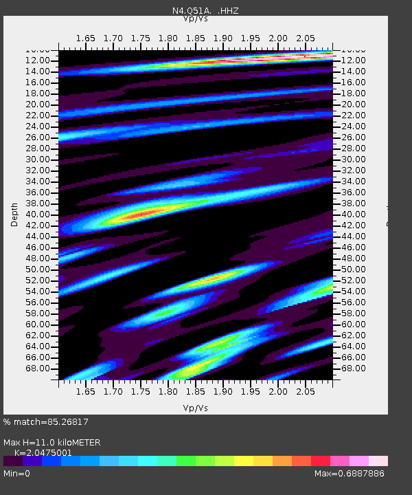
| Estimated Moho Depth: |
11.0 km |
| Estimated Crust Vp/Vs: |
2.05 |
| Assumed Crust Vp: |
6.232 km/s |
| Estimated Crust Vs: |
3.044 km/s |
| Estimated Crust Poisson's Ratio: |
0.34 |
|
| Radial Match: |
85.26817 % |
| Radial Bump: |
306 |
| Transverse Match: |
85.23438 % |
| Transverse Bump: |
318 |
| SOD ConfigId: |
769524 |
| Insert Time: |
2014-09-07 10:45:15.329 +0000 |
| GWidth: |
2.5 |
| Max Bumps: |
400 |
| Tol: |
0.001 |
|

Signal To Noise
| Channel | StoN | STA | LTA |
| N4:Q51A: :HHZ:20140824T10:26:25.409985Z | 4.7788706 | 2.8706353E-7 | 6.006932E-8 |
| N4:Q51A: :HHN:20140824T10:26:25.409985Z | 1.1758779 | 3.5520427E-9 | 3.020758E-9 |
| N4:Q51A: :HHE:20140824T10:26:25.409985Z | 3.9159331 | 2.5313517E-7 | 6.4642364E-8 |
| Arrivals |
| Ps | 2.0 SECOND |
| PpPs | 5.0 SECOND |
| PsPs/PpSs | 7.0 SECOND |


