You are here: Home > Network List > N4 - Central and EAstern US Network Stations List
> Station Y52A Lilburn, GA, USA > Earthquake Result Viewer
Y52A Lilburn, GA, USA - Earthquake Result Viewer
| Earthquake location: |
Northern California |
| Earthquake latitude/longitude: |
38.2/-122.3 |
| Earthquake time(UTC): |
2014/08/24 (236) 10:20:44 GMT |
| Earthquake Depth: |
7.8 km |
| Earthquake Magnitude: |
6.0 MW, 6.1 MI |
| Earthquake Catalog/Contributor: |
NEIC PDE/NEIC ALERT |
|
| Network: |
N4 Central and EAstern US Network |
| Station: |
Y52A Lilburn, GA, USA |
| Lat/Lon: |
33.86 N/84.06 W |
| Elevation: |
286 m |
|
| Distance: |
31.1 deg |
| Az: |
86.169 deg |
| Baz: |
289.155 deg |
| Ray Param: |
0.07916282 |
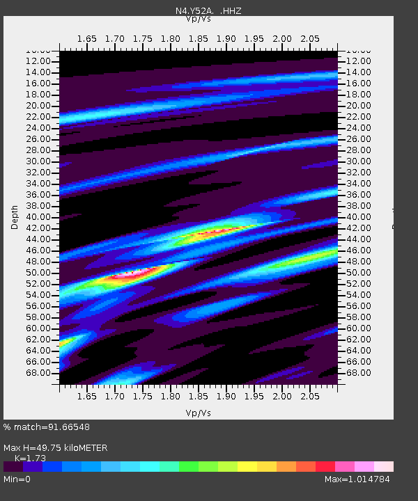
| Estimated Moho Depth: |
49.75 km |
| Estimated Crust Vp/Vs: |
1.73 |
| Assumed Crust Vp: |
6.719 km/s |
| Estimated Crust Vs: |
3.884 km/s |
| Estimated Crust Poisson's Ratio: |
0.25 |
|
| Radial Match: |
91.66548 % |
| Radial Bump: |
178 |
| Transverse Match: |
69.71536 % |
| Transverse Bump: |
382 |
| SOD ConfigId: |
769524 |
| Insert Time: |
2014-09-07 10:45:17.030 +0000 |
| GWidth: |
2.5 |
| Max Bumps: |
400 |
| Tol: |
0.001 |
|

Signal To Noise
| Channel | StoN | STA | LTA |
| N4:Y52A: :HHZ:20140824T10:26:32.300Z | 4.517019 | 2.6306682E-7 | 5.8239035E-8 |
| N4:Y52A: :HHN:20140824T10:26:32.300Z | 1.4700406 | 6.442029E-8 | 4.3822123E-8 |
| N4:Y52A: :HHE:20140824T10:26:32.300Z | 3.6709316 | 1.803202E-7 | 4.91211E-8 |
| Arrivals |
| Ps | 5.9 SECOND |
| PpPs | 18 SECOND |
| PsPs/PpSs | 24 SECOND |


