You are here: Home > Network List > TA - USArray Transportable Network (new EarthScope stations) Stations List
> Station D53A Lac Vacive, Pontiac, Mrc, QC, CAN > Earthquake Result Viewer
D53A Lac Vacive, Pontiac, Mrc, QC, CAN - Earthquake Result Viewer

| Earthquake location: |
Northern California |
| Earthquake latitude/longitude: |
38.2/-122.3 |
| Earthquake time(UTC): |
2014/08/24 (236) 10:20:44 GMT |
| Earthquake Depth: |
7.8 km |
| Earthquake Magnitude: |
6.0 MW, 6.1 MI |
| Earthquake Catalog/Contributor: |
NEIC PDE/NEIC ALERT |
|
| Network: |
TA USArray Transportable Network (new EarthScope stations) |
| Station: |
D53A Lac Vacive, Pontiac, Mrc, QC, CAN |
| Lat/Lon: |
47.08 N/77.70 W |
| Elevation: |
347 m |
|
| Distance: |
33.6 deg |
| Az: |
60.152 deg |
| Baz: |
271.206 deg |
| Ray Param: |
0.07813429 |
| Estimated Moho Depth: |
28.5 km |
| Estimated Crust Vp/Vs: |
2.10 |
| Assumed Crust Vp: |
6.622 km/s |
| Estimated Crust Vs: |
3.157 km/s |
| Estimated Crust Poisson's Ratio: |
0.35 |
|
| Radial Match: |
86.2621 % |
| Radial Bump: |
260 |
| Transverse Match: |
55.657185 % |
| Transverse Bump: |
400 |
| SOD ConfigId: |
769524 |
| Insert Time: |
2014-09-07 10:48:24.796 +0000 |
| GWidth: |
2.5 |
| Max Bumps: |
400 |
| Tol: |
0.001 |
|
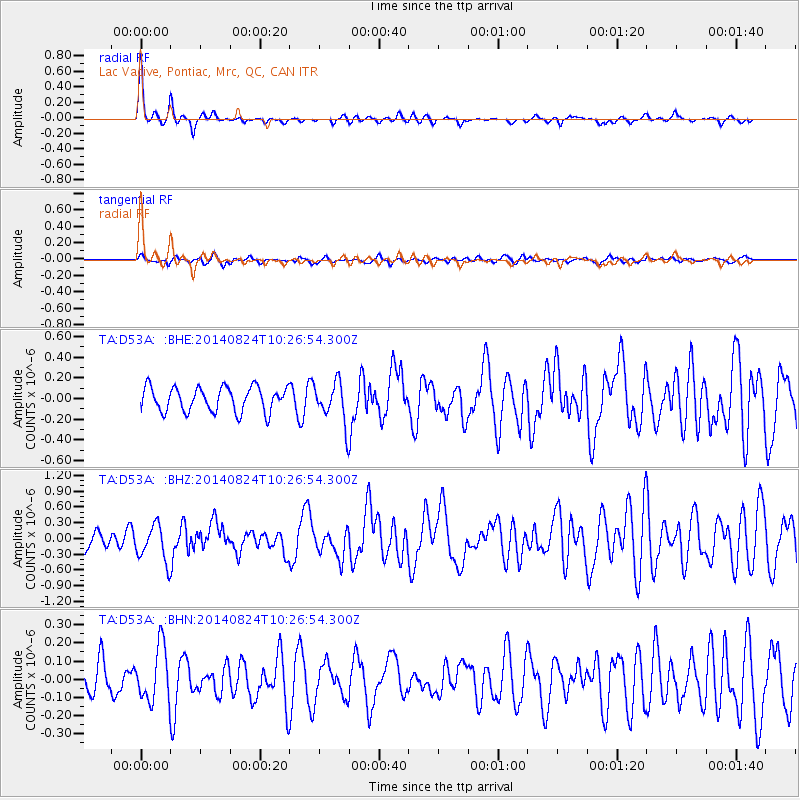
Signal To Noise
| Channel | StoN | STA | LTA |
| TA:D53A: :BHZ:20140824T10:26:54.300Z | 2.5338552 | 3.4831916E-7 | 1.3746609E-7 |
| TA:D53A: :BHN:20140824T10:26:54.300Z | 1.8149912 | 1.5064857E-7 | 8.300237E-8 |
| TA:D53A: :BHE:20140824T10:26:54.300Z | 1.6914378 | 1.9931414E-7 | 1.17837104E-7 |
| Arrivals |
| Ps | 5.1 SECOND |
| PpPs | 12 SECOND |
| PsPs/PpSs | 17 SECOND |


