You are here: Home > Network List > TA - USArray Transportable Network (new EarthScope stations) Stations List
> Station D57A Chemin Vers le Barrage, Saint-Michel-Des-Saints, Q > Earthquake Result Viewer
D57A Chemin Vers le Barrage, Saint-Michel-Des-Saints, Q - Earthquake Result Viewer

| Earthquake location: |
Northern California |
| Earthquake latitude/longitude: |
38.2/-122.3 |
| Earthquake time(UTC): |
2014/08/24 (236) 10:20:44 GMT |
| Earthquake Depth: |
7.8 km |
| Earthquake Magnitude: |
6.0 MW, 6.1 MI |
| Earthquake Catalog/Contributor: |
NEIC PDE/NEIC ALERT |
|
| Network: |
TA USArray Transportable Network (new EarthScope stations) |
| Station: |
D57A Chemin Vers le Barrage, Saint-Michel-Des-Saints, Q |
| Lat/Lon: |
47.02 N/73.89 W |
| Elevation: |
422 m |
|
| Distance: |
36.2 deg |
| Az: |
60.058 deg |
| Baz: |
273.911 deg |
| Ray Param: |
0.07680799 |
| Estimated Moho Depth: |
37.25 km |
| Estimated Crust Vp/Vs: |
1.91 |
| Assumed Crust Vp: |
6.61 km/s |
| Estimated Crust Vs: |
3.461 km/s |
| Estimated Crust Poisson's Ratio: |
0.31 |
|
| Radial Match: |
87.62189 % |
| Radial Bump: |
257 |
| Transverse Match: |
66.23645 % |
| Transverse Bump: |
400 |
| SOD ConfigId: |
769524 |
| Insert Time: |
2014-09-07 10:48:31.055 +0000 |
| GWidth: |
2.5 |
| Max Bumps: |
400 |
| Tol: |
0.001 |
|
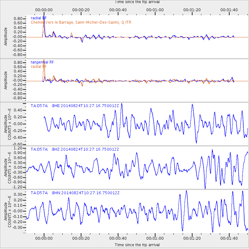
Signal To Noise
| Channel | StoN | STA | LTA |
| TA:D57A: :BHZ:20140824T10:27:16.750012Z | 2.8575587 | 3.2303168E-7 | 1.1304463E-7 |
| TA:D57A: :BHN:20140824T10:27:16.750012Z | 1.3379308 | 1.3193483E-7 | 9.86111E-8 |
| TA:D57A: :BHE:20140824T10:27:16.750012Z | 1.5468217 | 1.7954216E-7 | 1.16071654E-7 |
| Arrivals |
| Ps | 5.5 SECOND |
| PpPs | 15 SECOND |
| PsPs/PpSs | 21 SECOND |


