You are here: Home > Network List > TA - USArray Transportable Network (new EarthScope stations) Stations List
> Station E54A Lac Daplat, Pontiac, MRC, QC, CAN > Earthquake Result Viewer
E54A Lac Daplat, Pontiac, MRC, QC, CAN - Earthquake Result Viewer

| Earthquake location: |
Northern California |
| Earthquake latitude/longitude: |
38.2/-122.3 |
| Earthquake time(UTC): |
2014/08/24 (236) 10:20:44 GMT |
| Earthquake Depth: |
7.8 km |
| Earthquake Magnitude: |
6.0 MW, 6.1 MI |
| Earthquake Catalog/Contributor: |
NEIC PDE/NEIC ALERT |
|
| Network: |
TA USArray Transportable Network (new EarthScope stations) |
| Station: |
E54A Lac Daplat, Pontiac, MRC, QC, CAN |
| Lat/Lon: |
46.43 N/77.19 W |
| Elevation: |
277 m |
|
| Distance: |
34.0 deg |
| Az: |
61.292 deg |
| Baz: |
272.526 deg |
| Ray Param: |
0.0779622 |
| Estimated Moho Depth: |
39.75 km |
| Estimated Crust Vp/Vs: |
1.86 |
| Assumed Crust Vp: |
6.622 km/s |
| Estimated Crust Vs: |
3.56 km/s |
| Estimated Crust Poisson's Ratio: |
0.30 |
|
| Radial Match: |
89.75981 % |
| Radial Bump: |
266 |
| Transverse Match: |
78.58614 % |
| Transverse Bump: |
384 |
| SOD ConfigId: |
769524 |
| Insert Time: |
2014-09-07 10:48:43.835 +0000 |
| GWidth: |
2.5 |
| Max Bumps: |
400 |
| Tol: |
0.001 |
|
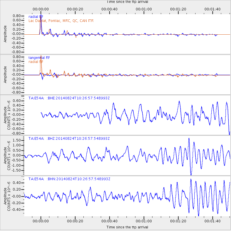
Signal To Noise
| Channel | StoN | STA | LTA |
| TA:E54A: :BHZ:20140824T10:26:57.548993Z | 3.413642 | 2.9093468E-7 | 8.5227065E-8 |
| TA:E54A: :BHN:20140824T10:26:57.548993Z | 0.9311963 | 8.060771E-8 | 8.656361E-8 |
| TA:E54A: :BHE:20140824T10:26:57.548993Z | 1.8539492 | 1.15463024E-7 | 6.22795E-8 |
| Arrivals |
| Ps | 5.6 SECOND |
| PpPs | 16 SECOND |
| PsPs/PpSs | 21 SECOND |


