You are here: Home > Network List > TA - USArray Transportable Network (new EarthScope stations) Stations List
> Station H58A Gabriels, NY, USA > Earthquake Result Viewer
H58A Gabriels, NY, USA - Earthquake Result Viewer
| Earthquake location: |
Northern California |
| Earthquake latitude/longitude: |
38.2/-122.3 |
| Earthquake time(UTC): |
2014/08/24 (236) 10:20:44 GMT |
| Earthquake Depth: |
7.8 km |
| Earthquake Magnitude: |
6.0 MW, 6.1 MI |
| Earthquake Catalog/Contributor: |
NEIC PDE/NEIC ALERT |
|
| Network: |
TA USArray Transportable Network (new EarthScope stations) |
| Station: |
H58A Gabriels, NY, USA |
| Lat/Lon: |
44.42 N/74.18 W |
| Elevation: |
537 m |
|
| Distance: |
36.3 deg |
| Az: |
64.469 deg |
| Baz: |
277.261 deg |
| Ray Param: |
0.07678103 |
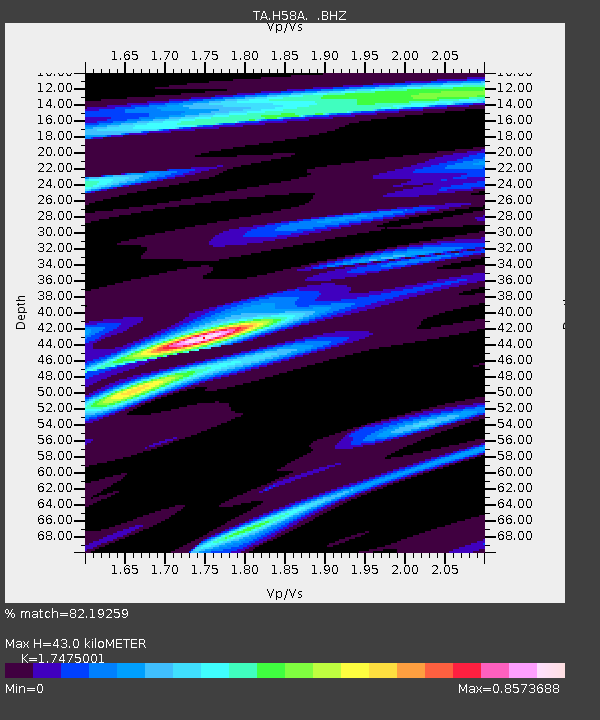
| Estimated Moho Depth: |
43.0 km |
| Estimated Crust Vp/Vs: |
1.75 |
| Assumed Crust Vp: |
6.419 km/s |
| Estimated Crust Vs: |
3.673 km/s |
| Estimated Crust Poisson's Ratio: |
0.26 |
|
| Radial Match: |
82.19259 % |
| Radial Bump: |
288 |
| Transverse Match: |
46.813683 % |
| Transverse Bump: |
365 |
| SOD ConfigId: |
769524 |
| Insert Time: |
2014-09-07 10:49:32.745 +0000 |
| GWidth: |
2.5 |
| Max Bumps: |
400 |
| Tol: |
0.001 |
|

Signal To Noise
| Channel | StoN | STA | LTA |
| TA:H58A: :BHZ:20140824T10:27:17.150006Z | 2.552099 | 2.3693327E-7 | 9.283859E-8 |
| TA:H58A: :BHN:20140824T10:27:17.150006Z | 1.0626109 | 1.2250253E-7 | 1.15284465E-7 |
| TA:H58A: :BHE:20140824T10:27:17.150006Z | 0.9264675 | 9.8180294E-8 | 1.0597274E-7 |
| Arrivals |
| Ps | 5.4 SECOND |
| PpPs | 17 SECOND |
| PsPs/PpSs | 22 SECOND |


