You are here: Home > Network List > TA - USArray Transportable Network (new EarthScope stations) Stations List
> Station I55A Frankford, ON, CAN > Earthquake Result Viewer
I55A Frankford, ON, CAN - Earthquake Result Viewer
| Earthquake location: |
Northern California |
| Earthquake latitude/longitude: |
38.2/-122.3 |
| Earthquake time(UTC): |
2014/08/24 (236) 10:20:44 GMT |
| Earthquake Depth: |
7.8 km |
| Earthquake Magnitude: |
6.0 MW, 6.1 MI |
| Earthquake Catalog/Contributor: |
NEIC PDE/NEIC ALERT |
|
| Network: |
TA USArray Transportable Network (new EarthScope stations) |
| Station: |
I55A Frankford, ON, CAN |
| Lat/Lon: |
44.22 N/77.68 W |
| Elevation: |
132 m |
|
| Distance: |
33.8 deg |
| Az: |
65.305 deg |
| Baz: |
275.507 deg |
| Ray Param: |
0.07805107 |
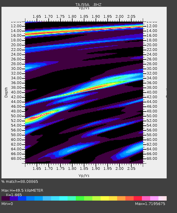
| Estimated Moho Depth: |
49.5 km |
| Estimated Crust Vp/Vs: |
1.66 |
| Assumed Crust Vp: |
6.577 km/s |
| Estimated Crust Vs: |
3.95 km/s |
| Estimated Crust Poisson's Ratio: |
0.22 |
|
| Radial Match: |
88.08865 % |
| Radial Bump: |
257 |
| Transverse Match: |
49.75758 % |
| Transverse Bump: |
399 |
| SOD ConfigId: |
769524 |
| Insert Time: |
2014-09-07 10:49:42.293 +0000 |
| GWidth: |
2.5 |
| Max Bumps: |
400 |
| Tol: |
0.001 |
|
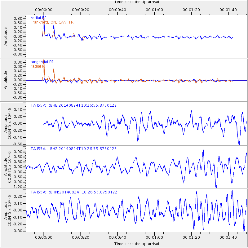
Signal To Noise
| Channel | StoN | STA | LTA |
| TA:I55A: :BHZ:20140824T10:26:55.875012Z | 2.53617 | 1.9870635E-7 | 7.834899E-8 |
| TA:I55A: :BHN:20140824T10:26:55.875012Z | 0.7559062 | 5.6692066E-8 | 7.499881E-8 |
| TA:I55A: :BHE:20140824T10:26:55.875012Z | 2.7658868 | 1.9081861E-7 | 6.899003E-8 |
| Arrivals |
| Ps | 5.5 SECOND |
| PpPs | 18 SECOND |
| PsPs/PpSs | 24 SECOND |


