You are here: Home > Network List > TA - USArray Transportable Network (new EarthScope stations) Stations List
> Station K59A Cooperstown, NY, USA > Earthquake Result Viewer
K59A Cooperstown, NY, USA - Earthquake Result Viewer
| Earthquake location: |
Northern California |
| Earthquake latitude/longitude: |
38.2/-122.3 |
| Earthquake time(UTC): |
2014/08/24 (236) 10:20:44 GMT |
| Earthquake Depth: |
7.8 km |
| Earthquake Magnitude: |
6.0 MW, 6.1 MI |
| Earthquake Catalog/Contributor: |
NEIC PDE/NEIC ALERT |
|
| Network: |
TA USArray Transportable Network (new EarthScope stations) |
| Station: |
K59A Cooperstown, NY, USA |
| Lat/Lon: |
42.78 N/74.85 W |
| Elevation: |
570 m |
|
| Distance: |
36.0 deg |
| Az: |
67.343 deg |
| Baz: |
279.12 deg |
| Ray Param: |
0.07691717 |
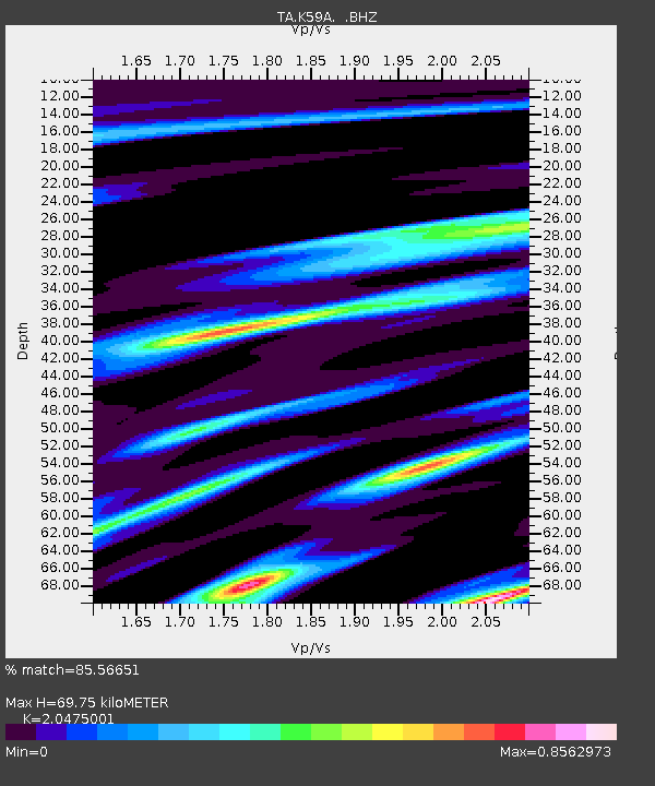
| Estimated Moho Depth: |
69.75 km |
| Estimated Crust Vp/Vs: |
2.05 |
| Assumed Crust Vp: |
6.419 km/s |
| Estimated Crust Vs: |
3.135 km/s |
| Estimated Crust Poisson's Ratio: |
0.34 |
|
| Radial Match: |
85.56651 % |
| Radial Bump: |
274 |
| Transverse Match: |
43.74783 % |
| Transverse Bump: |
353 |
| SOD ConfigId: |
769524 |
| Insert Time: |
2014-09-07 10:50:18.617 +0000 |
| GWidth: |
2.5 |
| Max Bumps: |
400 |
| Tol: |
0.001 |
|

Signal To Noise
| Channel | StoN | STA | LTA |
| TA:K59A: :BHZ:20140824T10:27:15.025006Z | 1.6950164 | 2.5206404E-7 | 1.487089E-7 |
| TA:K59A: :BHN:20140824T10:27:15.025006Z | 0.42278042 | 5.3816944E-8 | 1.2729289E-7 |
| TA:K59A: :BHE:20140824T10:27:15.025006Z | 0.90773815 | 1.0563238E-7 | 1.1636878E-7 |
| Arrivals |
| Ps | 12 SECOND |
| PpPs | 31 SECOND |
| PsPs/PpSs | 43 SECOND |


