You are here: Home > Network List > TA - USArray Transportable Network (new EarthScope stations) Stations List
> Station M61A Granite Springs, NY, USA > Earthquake Result Viewer
M61A Granite Springs, NY, USA - Earthquake Result Viewer
| Earthquake location: |
Northern California |
| Earthquake latitude/longitude: |
38.2/-122.3 |
| Earthquake time(UTC): |
2014/08/24 (236) 10:20:44 GMT |
| Earthquake Depth: |
7.8 km |
| Earthquake Magnitude: |
6.0 MW, 6.1 MI |
| Earthquake Catalog/Contributor: |
NEIC PDE/NEIC ALERT |
|
| Network: |
TA USArray Transportable Network (new EarthScope stations) |
| Station: |
M61A Granite Springs, NY, USA |
| Lat/Lon: |
41.31 N/73.77 W |
| Elevation: |
190 m |
|
| Distance: |
37.1 deg |
| Az: |
69.517 deg |
| Baz: |
281.591 deg |
| Ray Param: |
0.07634054 |
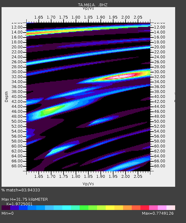
| Estimated Moho Depth: |
31.75 km |
| Estimated Crust Vp/Vs: |
1.97 |
| Assumed Crust Vp: |
6.472 km/s |
| Estimated Crust Vs: |
3.281 km/s |
| Estimated Crust Poisson's Ratio: |
0.33 |
|
| Radial Match: |
83.94333 % |
| Radial Bump: |
400 |
| Transverse Match: |
37.190018 % |
| Transverse Bump: |
400 |
| SOD ConfigId: |
769524 |
| Insert Time: |
2014-09-07 10:50:51.508 +0000 |
| GWidth: |
2.5 |
| Max Bumps: |
400 |
| Tol: |
0.001 |
|

Signal To Noise
| Channel | StoN | STA | LTA |
| TA:M61A: :BHZ:20140824T10:27:24.025006Z | 1.8772604 | 2.596682E-7 | 1.3832296E-7 |
| TA:M61A: :BHN:20140824T10:27:24.025006Z | 0.7134715 | 8.499418E-8 | 1.1912765E-7 |
| TA:M61A: :BHE:20140824T10:27:24.025006Z | 2.4309428 | 2.7584494E-7 | 1.1347241E-7 |
| Arrivals |
| Ps | 5.1 SECOND |
| PpPs | 14 SECOND |
| PsPs/PpSs | 19 SECOND |


