You are here: Home > Network List > TA - USArray Transportable Network (new EarthScope stations) Stations List
> Station O52A Adamsville, OH, USA > Earthquake Result Viewer
O52A Adamsville, OH, USA - Earthquake Result Viewer
| Earthquake location: |
Northern California |
| Earthquake latitude/longitude: |
38.2/-122.3 |
| Earthquake time(UTC): |
2014/08/24 (236) 10:20:44 GMT |
| Earthquake Depth: |
7.8 km |
| Earthquake Magnitude: |
6.0 MW, 6.1 MI |
| Earthquake Catalog/Contributor: |
NEIC PDE/NEIC ALERT |
|
| Network: |
TA USArray Transportable Network (new EarthScope stations) |
| Station: |
O52A Adamsville, OH, USA |
| Lat/Lon: |
40.12 N/81.84 W |
| Elevation: |
331 m |
|
| Distance: |
31.3 deg |
| Az: |
73.621 deg |
| Baz: |
279.743 deg |
| Ray Param: |
0.07911782 |
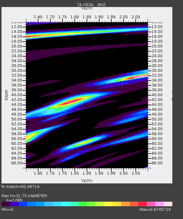
| Estimated Moho Depth: |
31.75 km |
| Estimated Crust Vp/Vs: |
2.10 |
| Assumed Crust Vp: |
6.483 km/s |
| Estimated Crust Vs: |
3.094 km/s |
| Estimated Crust Poisson's Ratio: |
0.35 |
|
| Radial Match: |
80.49716 % |
| Radial Bump: |
304 |
| Transverse Match: |
53.27638 % |
| Transverse Bump: |
400 |
| SOD ConfigId: |
769524 |
| Insert Time: |
2014-09-07 10:51:12.489 +0000 |
| GWidth: |
2.5 |
| Max Bumps: |
400 |
| Tol: |
0.001 |
|

Signal To Noise
| Channel | StoN | STA | LTA |
| TA:O52A: :BHZ:20140824T10:26:33.824994Z | 2.9411323 | 2.6736666E-7 | 9.0906035E-8 |
| TA:O52A: :BHN:20140824T10:26:33.824994Z | 0.97509336 | 8.59015E-8 | 8.809566E-8 |
| TA:O52A: :BHE:20140824T10:26:33.824994Z | 1.9235333 | 1.4354616E-7 | 7.462629E-8 |
| Arrivals |
| Ps | 5.7 SECOND |
| PpPs | 14 SECOND |
| PsPs/PpSs | 20 SECOND |


