You are here: Home > Network List > TA - USArray Transportable Network (new EarthScope stations) Stations List
> Station P57A Homestead Farm, Martinsburg, WV, USA > Earthquake Result Viewer
P57A Homestead Farm, Martinsburg, WV, USA - Earthquake Result Viewer
| Earthquake location: |
Northern California |
| Earthquake latitude/longitude: |
38.2/-122.3 |
| Earthquake time(UTC): |
2014/08/24 (236) 10:20:44 GMT |
| Earthquake Depth: |
7.8 km |
| Earthquake Magnitude: |
6.0 MW, 6.1 MI |
| Earthquake Catalog/Contributor: |
NEIC PDE/NEIC ALERT |
|
| Network: |
TA USArray Transportable Network (new EarthScope stations) |
| Station: |
P57A Homestead Farm, Martinsburg, WV, USA |
| Lat/Lon: |
39.48 N/78.01 W |
| Elevation: |
191 m |
|
| Distance: |
34.3 deg |
| Az: |
73.727 deg |
| Baz: |
282.27 deg |
| Ray Param: |
0.077826545 |
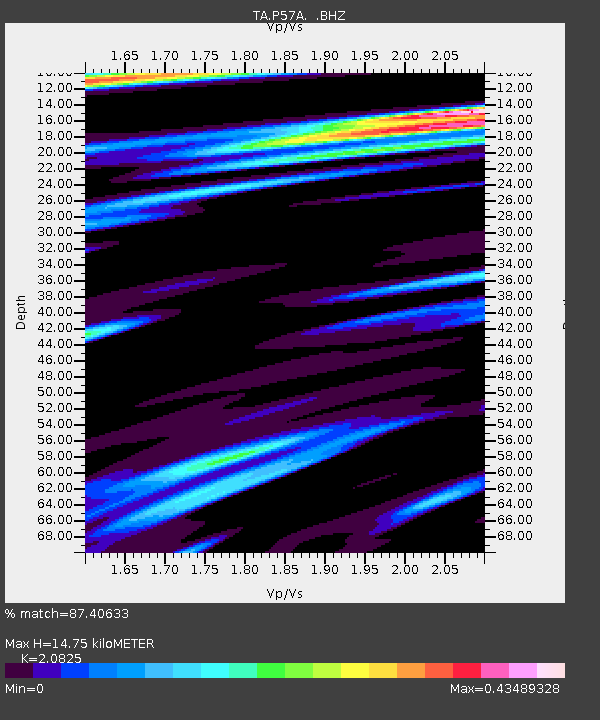
| Estimated Moho Depth: |
14.75 km |
| Estimated Crust Vp/Vs: |
2.08 |
| Assumed Crust Vp: |
6.159 km/s |
| Estimated Crust Vs: |
2.957 km/s |
| Estimated Crust Poisson's Ratio: |
0.35 |
|
| Radial Match: |
87.40633 % |
| Radial Bump: |
369 |
| Transverse Match: |
45.889645 % |
| Transverse Bump: |
400 |
| SOD ConfigId: |
769524 |
| Insert Time: |
2014-09-07 10:51:42.480 +0000 |
| GWidth: |
2.5 |
| Max Bumps: |
400 |
| Tol: |
0.001 |
|
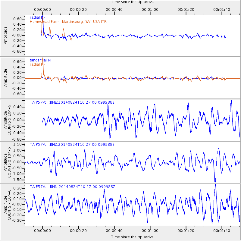
Signal To Noise
| Channel | StoN | STA | LTA |
| TA:P57A: :BHZ:20140824T10:27:00.099988Z | 3.9703908 | 3.7640237E-7 | 9.4802346E-8 |
| TA:P57A: :BHN:20140824T10:27:00.099988Z | 1.2467763 | 1.01626625E-7 | 8.1511516E-8 |
| TA:P57A: :BHE:20140824T10:27:00.099988Z | 1.9023734 | 1.5655354E-7 | 8.2293795E-8 |
| Arrivals |
| Ps | 2.8 SECOND |
| PpPs | 7.0 SECOND |
| PsPs/PpSs | 9.7 SECOND |


