You are here: Home > Network List > TA - USArray Transportable Network (new EarthScope stations) Stations List
> Station Q55A Buckhannon, WV, USA > Earthquake Result Viewer
Q55A Buckhannon, WV, USA - Earthquake Result Viewer
| Earthquake location: |
Northern California |
| Earthquake latitude/longitude: |
38.2/-122.3 |
| Earthquake time(UTC): |
2014/08/24 (236) 10:20:44 GMT |
| Earthquake Depth: |
7.8 km |
| Earthquake Magnitude: |
6.0 MW, 6.1 MI |
| Earthquake Catalog/Contributor: |
NEIC PDE/NEIC ALERT |
|
| Network: |
TA USArray Transportable Network (new EarthScope stations) |
| Station: |
Q55A Buckhannon, WV, USA |
| Lat/Lon: |
39.00 N/80.08 W |
| Elevation: |
657 m |
|
| Distance: |
32.8 deg |
| Az: |
75.205 deg |
| Baz: |
282.199 deg |
| Ray Param: |
0.07849837 |
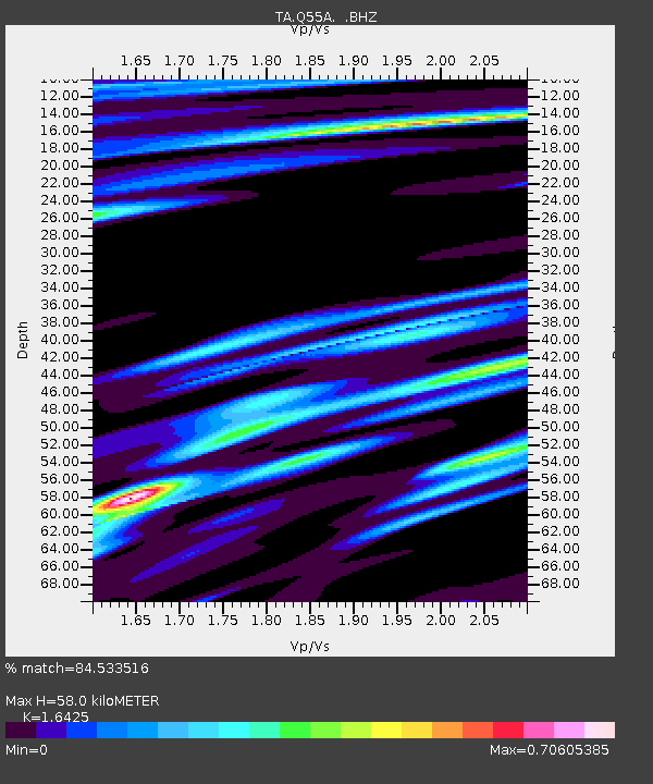
| Estimated Moho Depth: |
58.0 km |
| Estimated Crust Vp/Vs: |
1.64 |
| Assumed Crust Vp: |
6.207 km/s |
| Estimated Crust Vs: |
3.779 km/s |
| Estimated Crust Poisson's Ratio: |
0.21 |
|
| Radial Match: |
84.533516 % |
| Radial Bump: |
400 |
| Transverse Match: |
68.54206 % |
| Transverse Bump: |
400 |
| SOD ConfigId: |
769524 |
| Insert Time: |
2014-09-07 10:52:02.584 +0000 |
| GWidth: |
2.5 |
| Max Bumps: |
400 |
| Tol: |
0.001 |
|

Signal To Noise
| Channel | StoN | STA | LTA |
| TA:Q55A: :BHZ:20140824T10:26:47.349988Z | 3.1310706 | 4.2326846E-7 | 1.351833E-7 |
| TA:Q55A: :BHN:20140824T10:26:47.349988Z | 0.9932429 | 8.985976E-8 | 9.047108E-8 |
| TA:Q55A: :BHE:20140824T10:26:47.349988Z | 2.3289137 | 2.0026417E-7 | 8.599037E-8 |
| Arrivals |
| Ps | 6.5 SECOND |
| PpPs | 23 SECOND |
| PsPs/PpSs | 29 SECOND |


