You are here: Home > Network List > TA - USArray Transportable Network (new EarthScope stations) Stations List
> Station R53A Hurricane, WV, USA > Earthquake Result Viewer
R53A Hurricane, WV, USA - Earthquake Result Viewer

| Earthquake location: |
Northern California |
| Earthquake latitude/longitude: |
38.2/-122.3 |
| Earthquake time(UTC): |
2014/08/24 (236) 10:20:44 GMT |
| Earthquake Depth: |
7.8 km |
| Earthquake Magnitude: |
6.0 MW, 6.1 MI |
| Earthquake Catalog/Contributor: |
NEIC PDE/NEIC ALERT |
|
| Network: |
TA USArray Transportable Network (new EarthScope stations) |
| Station: |
R53A Hurricane, WV, USA |
| Lat/Lon: |
38.33 N/81.95 W |
| Elevation: |
294 m |
|
| Distance: |
31.5 deg |
| Az: |
77.012 deg |
| Baz: |
282.566 deg |
| Ray Param: |
0.079046085 |
| Estimated Moho Depth: |
16.75 km |
| Estimated Crust Vp/Vs: |
2.10 |
| Assumed Crust Vp: |
6.207 km/s |
| Estimated Crust Vs: |
2.959 km/s |
| Estimated Crust Poisson's Ratio: |
0.35 |
|
| Radial Match: |
82.52885 % |
| Radial Bump: |
400 |
| Transverse Match: |
49.03668 % |
| Transverse Bump: |
400 |
| SOD ConfigId: |
769524 |
| Insert Time: |
2014-09-07 10:52:13.204 +0000 |
| GWidth: |
2.5 |
| Max Bumps: |
400 |
| Tol: |
0.001 |
|
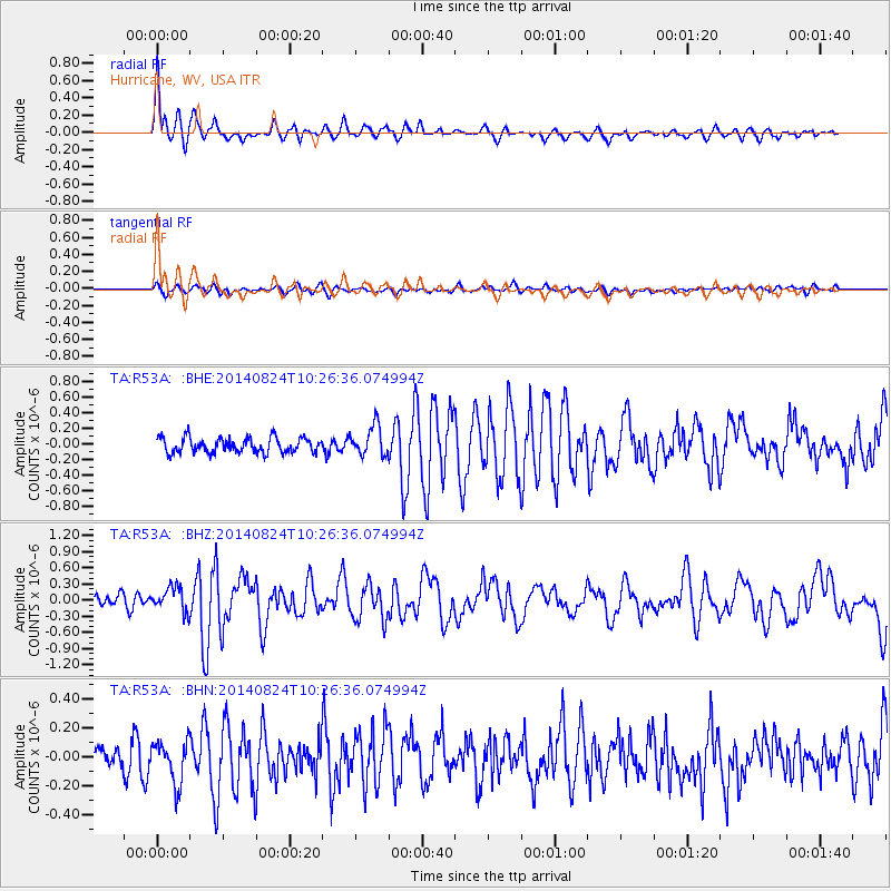
Signal To Noise
| Channel | StoN | STA | LTA |
| TA:R53A: :BHZ:20140824T10:26:36.074994Z | 1.7488831 | 2.2457013E-7 | 1.2840773E-7 |
| TA:R53A: :BHN:20140824T10:26:36.074994Z | 1.5262295 | 1.4351204E-7 | 9.403045E-8 |
| TA:R53A: :BHE:20140824T10:26:36.074994Z | 2.0391965 | 1.9458957E-7 | 9.5424625E-8 |
| Arrivals |
| Ps | 3.2 SECOND |
| PpPs | 7.9 SECOND |
| PsPs/PpSs | 11 SECOND |


