You are here: Home > Network List > TA - USArray Transportable Network (new EarthScope stations) Stations List
> Station T57A Hurt, VA, USA > Earthquake Result Viewer
T57A Hurt, VA, USA - Earthquake Result Viewer
| Earthquake location: |
Northern California |
| Earthquake latitude/longitude: |
38.2/-122.3 |
| Earthquake time(UTC): |
2014/08/24 (236) 10:20:44 GMT |
| Earthquake Depth: |
7.8 km |
| Earthquake Magnitude: |
6.0 MW, 6.1 MI |
| Earthquake Catalog/Contributor: |
NEIC PDE/NEIC ALERT |
|
| Network: |
TA USArray Transportable Network (new EarthScope stations) |
| Station: |
T57A Hurt, VA, USA |
| Lat/Lon: |
37.00 N/79.25 W |
| Elevation: |
230 m |
|
| Distance: |
33.9 deg |
| Az: |
78.442 deg |
| Baz: |
285.411 deg |
| Ray Param: |
0.077990375 |
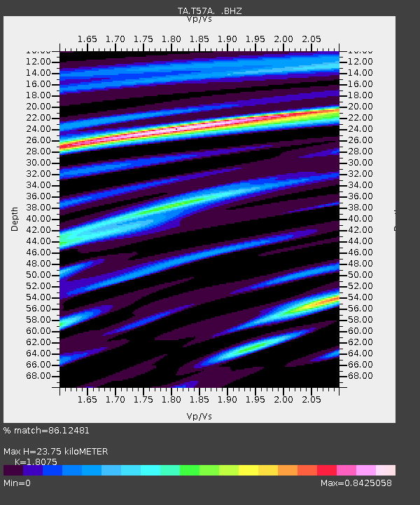
| Estimated Moho Depth: |
23.75 km |
| Estimated Crust Vp/Vs: |
1.81 |
| Assumed Crust Vp: |
6.419 km/s |
| Estimated Crust Vs: |
3.551 km/s |
| Estimated Crust Poisson's Ratio: |
0.28 |
|
| Radial Match: |
86.12481 % |
| Radial Bump: |
348 |
| Transverse Match: |
57.770847 % |
| Transverse Bump: |
400 |
| SOD ConfigId: |
769524 |
| Insert Time: |
2014-09-07 10:52:56.772 +0000 |
| GWidth: |
2.5 |
| Max Bumps: |
400 |
| Tol: |
0.001 |
|
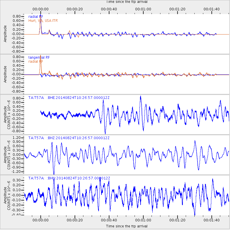
Signal To Noise
| Channel | StoN | STA | LTA |
| TA:T57A: :BHZ:20140824T10:26:57.000012Z | 2.2423196 | 2.6850753E-7 | 1.1974544E-7 |
| TA:T57A: :BHN:20140824T10:26:57.000012Z | 1.7345082 | 9.875241E-8 | 5.6933956E-8 |
| TA:T57A: :BHE:20140824T10:26:57.000012Z | 1.9420066 | 1.5925315E-7 | 8.200443E-8 |
| Arrivals |
| Ps | 3.2 SECOND |
| PpPs | 9.6 SECOND |
| PsPs/PpSs | 13 SECOND |


