You are here: Home > Network List > TA - USArray Transportable Network (new EarthScope stations) Stations List
> Station Z41A Richland Creek Farm, El Dorado, AR, USA > Earthquake Result Viewer
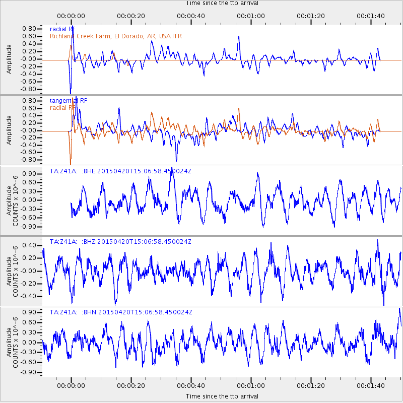
Z41A Richland Creek Farm, El Dorado, AR, USA - Earthquake Result Viewer
*The percent match for this event was below the threshold and hence no stack was calculated.
| Earthquake location: |
Kuril Islands |
| Earthquake latitude/longitude: |
46.2/151.6 |
| Earthquake time(UTC): |
2015/04/20 (110) 14:55:21 GMT |
| Earthquake Depth: |
100 km |
| Earthquake Magnitude: |
4.4 mb, 4.4 mb |
| Earthquake Catalog/Contributor: |
ISC/ISC |
|
| Network: |
TA USArray Transportable Network (new EarthScope stations) |
| Station: |
Z41A Richland Creek Farm, El Dorado, AR, USA |
| Lat/Lon: |
33.26 N/92.80 W |
| Elevation: |
62 m |
|
| Distance: |
81.9 deg |
| Az: |
49.727 deg |
| Baz: |
320.759 deg |
| Ray Param: |
$rayparam |
*The percent match for this event was below the threshold and hence was not used in the summary stack. |
|
| Radial Match: |
45.582005 % |
| Radial Bump: |
400 |
| Transverse Match: |
49.510563 % |
| Transverse Bump: |
400 |
| SOD ConfigId: |
7422571 |
| Insert Time: |
2019-04-18 06:58:48.263 +0000 |
| GWidth: |
2.5 |
| Max Bumps: |
400 |
| Tol: |
0.001 |
|
Signal To Noise
| Channel | StoN | STA | LTA |
| TA:Z41A: :BHZ:20150420T15:06:58.450024Z | 1.2601662 | 2.2514465E-7 | 1.7866267E-7 |
| TA:Z41A: :BHN:20150420T15:06:58.450024Z | 0.6219179 | 2.3598584E-7 | 3.7944852E-7 |
| TA:Z41A: :BHE:20150420T15:06:58.450024Z | 1.9313585 | 5.5743396E-7 | 2.8862274E-7 |
| Arrivals |
| Ps | |
| PpPs | |
| PsPs/PpSs | |


