You are here: Home > Network List > TA - USArray Transportable Network (new EarthScope stations) Stations List
> Station TCOL CIGO, UAF Yankovich Road, Fairbanks, AK, USA > Earthquake Result Viewer
TCOL CIGO, UAF Yankovich Road, Fairbanks, AK, USA - Earthquake Result Viewer
| Earthquake location: |
Northern California |
| Earthquake latitude/longitude: |
38.2/-122.3 |
| Earthquake time(UTC): |
2014/08/24 (236) 10:20:44 GMT |
| Earthquake Depth: |
7.8 km |
| Earthquake Magnitude: |
6.0 MW, 6.1 MI |
| Earthquake Catalog/Contributor: |
NEIC PDE/NEIC ALERT |
|
| Network: |
TA USArray Transportable Network (new EarthScope stations) |
| Station: |
TCOL CIGO, UAF Yankovich Road, Fairbanks, AK, USA |
| Lat/Lon: |
64.87 N/147.86 W |
| Elevation: |
178 m |
|
| Distance: |
30.6 deg |
| Az: |
338.821 deg |
| Baz: |
138.195 deg |
| Ray Param: |
0.07928445 |
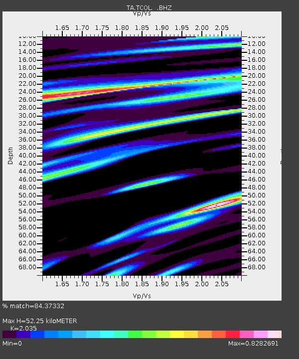
| Estimated Moho Depth: |
52.25 km |
| Estimated Crust Vp/Vs: |
2.04 |
| Assumed Crust Vp: |
6.566 km/s |
| Estimated Crust Vs: |
3.227 km/s |
| Estimated Crust Poisson's Ratio: |
0.34 |
|
| Radial Match: |
84.37332 % |
| Radial Bump: |
400 |
| Transverse Match: |
63.97227 % |
| Transverse Bump: |
400 |
| SOD ConfigId: |
769524 |
| Insert Time: |
2014-09-07 10:53:03.713 +0000 |
| GWidth: |
2.5 |
| Max Bumps: |
400 |
| Tol: |
0.001 |
|

Signal To Noise
| Channel | StoN | STA | LTA |
| TA:TCOL: :BHZ:20140824T10:26:28.224988Z | 2.6260288 | 1.7276005E-7 | 6.578757E-8 |
| TA:TCOL: :BHN:20140824T10:26:28.224988Z | 0.710759 | 5.7086712E-8 | 8.031797E-8 |
| TA:TCOL: :BHE:20140824T10:26:28.224988Z | 0.85781294 | 7.1878404E-8 | 8.379263E-8 |
| Arrivals |
| Ps | 8.9 SECOND |
| PpPs | 22 SECOND |
| PsPs/PpSs | 31 SECOND |


