You are here: Home > Network List > US - United States National Seismic Network Stations List
> Station AMTX Amarillo, Texas, USA > Earthquake Result Viewer
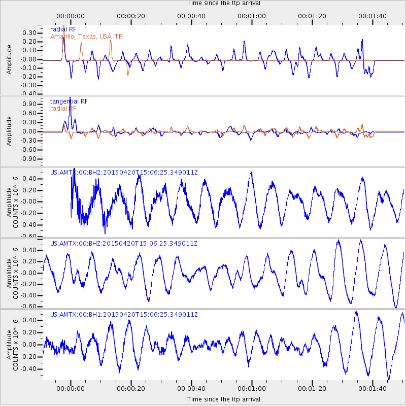
AMTX Amarillo, Texas, USA - Earthquake Result Viewer
*The percent match for this event was below the threshold and hence no stack was calculated.
| Earthquake location: |
Kuril Islands |
| Earthquake latitude/longitude: |
46.2/151.6 |
| Earthquake time(UTC): |
2015/04/20 (110) 14:55:21 GMT |
| Earthquake Depth: |
100 km |
| Earthquake Magnitude: |
4.4 mb, 4.4 mb |
| Earthquake Catalog/Contributor: |
ISC/ISC |
|
| Network: |
US United States National Seismic Network |
| Station: |
AMTX Amarillo, Texas, USA |
| Lat/Lon: |
34.53 N/101.41 W |
| Elevation: |
1010 m |
|
| Distance: |
76.2 deg |
| Az: |
54.36 deg |
| Baz: |
316.855 deg |
| Ray Param: |
$rayparam |
*The percent match for this event was below the threshold and hence was not used in the summary stack. |
|
| Radial Match: |
65.94504 % |
| Radial Bump: |
400 |
| Transverse Match: |
81.59874 % |
| Transverse Bump: |
324 |
| SOD ConfigId: |
7422571 |
| Insert Time: |
2019-04-18 06:59:07.915 +0000 |
| GWidth: |
2.5 |
| Max Bumps: |
400 |
| Tol: |
0.001 |
|
Signal To Noise
| Channel | StoN | STA | LTA |
| US:AMTX:00:BHZ:20150420T15:06:25.349011Z | 1.1167709 | 1.6984757E-7 | 1.5208812E-7 |
| US:AMTX:00:BH1:20150420T15:06:25.349011Z | 1.110353 | 1.314628E-7 | 1.183973E-7 |
| US:AMTX:00:BH2:20150420T15:06:25.349011Z | 1.019549 | 2.40769E-7 | 2.3615245E-7 |
| Arrivals |
| Ps | |
| PpPs | |
| PsPs/PpSs | |


