You are here: Home > Network List > TA - USArray Transportable Network (new EarthScope stations) Stations List
> Station Z56A Williston, SC, USA > Earthquake Result Viewer
Z56A Williston, SC, USA - Earthquake Result Viewer
| Earthquake location: |
Northern California |
| Earthquake latitude/longitude: |
38.2/-122.3 |
| Earthquake time(UTC): |
2014/08/24 (236) 10:20:44 GMT |
| Earthquake Depth: |
7.8 km |
| Earthquake Magnitude: |
6.0 MW, 6.1 MI |
| Earthquake Catalog/Contributor: |
NEIC PDE/NEIC ALERT |
|
| Network: |
TA USArray Transportable Network (new EarthScope stations) |
| Station: |
Z56A Williston, SC, USA |
| Lat/Lon: |
33.33 N/81.37 W |
| Elevation: |
81 m |
|
| Distance: |
33.4 deg |
| Az: |
85.697 deg |
| Baz: |
290.239 deg |
| Ray Param: |
0.078234084 |
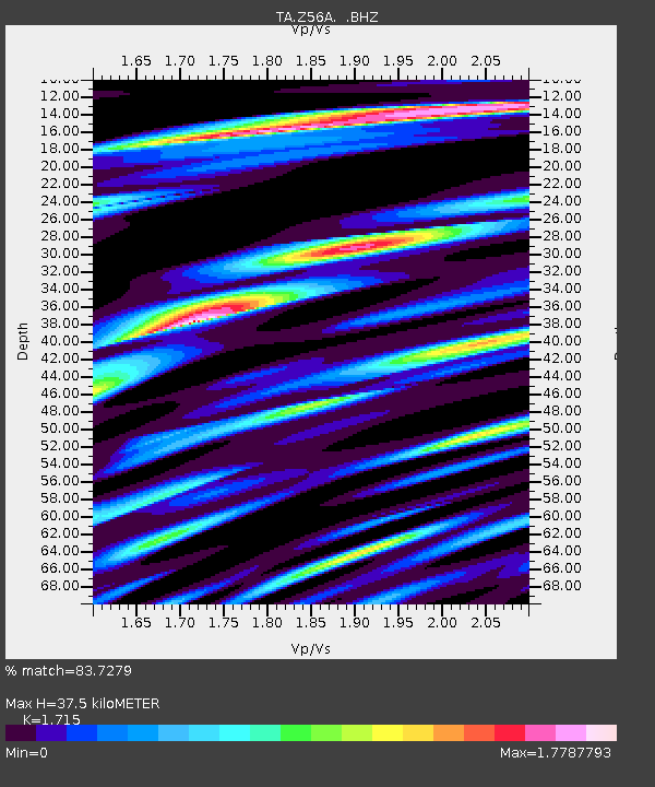
| Estimated Moho Depth: |
37.5 km |
| Estimated Crust Vp/Vs: |
1.72 |
| Assumed Crust Vp: |
6.565 km/s |
| Estimated Crust Vs: |
3.828 km/s |
| Estimated Crust Poisson's Ratio: |
0.24 |
|
| Radial Match: |
83.7279 % |
| Radial Bump: |
400 |
| Transverse Match: |
72.28387 % |
| Transverse Bump: |
400 |
| SOD ConfigId: |
769524 |
| Insert Time: |
2014-09-07 10:54:06.849 +0000 |
| GWidth: |
2.5 |
| Max Bumps: |
400 |
| Tol: |
0.001 |
|

Signal To Noise
| Channel | StoN | STA | LTA |
| TA:Z56A: :BHZ:20140824T10:26:52.423993Z | 2.7028825 | 2.8417494E-7 | 1.0513773E-7 |
| TA:Z56A: :BHN:20140824T10:26:52.423993Z | 1.4409599 | 3.1444264E-7 | 2.182175E-7 |
| TA:Z56A: :BHE:20140824T10:26:52.423993Z | 1.8324528 | 4.8708984E-7 | 2.6581301E-7 |
| Arrivals |
| Ps | 4.4 SECOND |
| PpPs | 14 SECOND |
| PsPs/PpSs | 19 SECOND |


