You are here: Home > Network List > X812 - Deep Structure of Three Continental Sutures in Eastern North America Stations List
> Station QM12 Camp Vic, Maine, USA > Earthquake Result Viewer
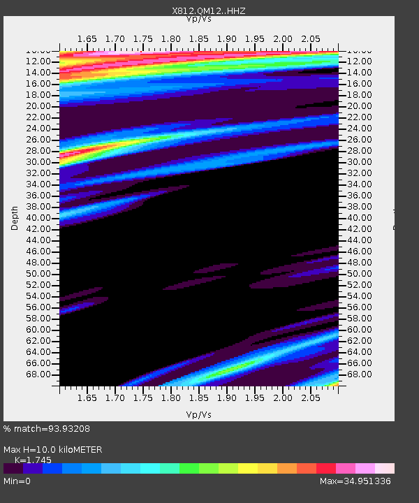
QM12 Camp Vic, Maine, USA - Earthquake Result Viewer
| Earthquake location: |
Kuril Islands |
| Earthquake latitude/longitude: |
46.2/151.6 |
| Earthquake time(UTC): |
2015/04/20 (110) 14:55:21 GMT |
| Earthquake Depth: |
100 km |
| Earthquake Magnitude: |
4.4 mb, 4.4 mb |
| Earthquake Catalog/Contributor: |
ISC/ISC |
|
| Network: |
X8 Deep Structure of Three Continental Sutures in Eastern North America |
| Station: |
QM12 Camp Vic, Maine, USA |
| Lat/Lon: |
44.97 N/67.86 W |
| Elevation: |
15 m |
|
| Distance: |
82.8 deg |
| Az: |
27.022 deg |
| Baz: |
333.599 deg |
| Ray Param: |
0.046436347 |
| Estimated Moho Depth: |
10.0 km |
| Estimated Crust Vp/Vs: |
1.75 |
| Assumed Crust Vp: |
6.419 km/s |
| Estimated Crust Vs: |
3.679 km/s |
| Estimated Crust Poisson's Ratio: |
0.26 |
|
| Radial Match: |
93.93208 % |
| Radial Bump: |
367 |
| Transverse Match: |
96.2101 % |
| Transverse Bump: |
364 |
| SOD ConfigId: |
7422571 |
| Insert Time: |
2019-04-18 06:59:43.891 +0000 |
| GWidth: |
2.5 |
| Max Bumps: |
400 |
| Tol: |
0.001 |
|

Signal To Noise
| Channel | StoN | STA | LTA |
| X8:QM12: :HHZ:20150420T15:07:02.940015Z | 2.7274773 | 2.5411564E-6 | 9.316874E-7 |
| X8:QM12: :HHN:20150420T15:07:02.940015Z | 1.1973149 | 4.198371E-5 | 3.5064888E-5 |
| X8:QM12: :HHE:20150420T15:07:02.940015Z | 2.1392238 | 2.910623E-4 | 1.3605977E-4 |
| Arrivals |
| Ps | 1.2 SECOND |
| PpPs | 4.2 SECOND |
| PsPs/PpSs | 5.4 SECOND |


