You are here: Home > Network List > CU - Caribbean Network (USGS) Stations List
> Station BBGH Gun Hill, Barbados > Earthquake Result Viewer
BBGH Gun Hill, Barbados - Earthquake Result Viewer
| Earthquake location: |
Central Peru |
| Earthquake latitude/longitude: |
-14.6/-73.6 |
| Earthquake time(UTC): |
2014/08/24 (236) 23:21:45 GMT |
| Earthquake Depth: |
101 km |
| Earthquake Magnitude: |
6.9 MWW, 6.8 MI, 6.9 MWB |
| Earthquake Catalog/Contributor: |
NEIC PDE/NEIC COMCAT |
|
| Network: |
CU Caribbean Network (USGS) |
| Station: |
BBGH Gun Hill, Barbados |
| Lat/Lon: |
13.14 N/59.56 W |
| Elevation: |
180 m |
|
| Distance: |
30.9 deg |
| Az: |
27.398 deg |
| Baz: |
207.217 deg |
| Ray Param: |
0.07905767 |
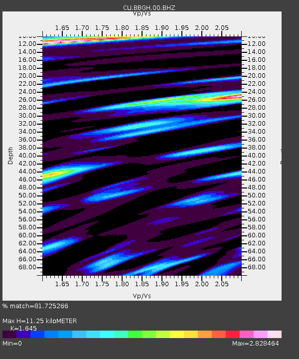
| Estimated Moho Depth: |
11.25 km |
| Estimated Crust Vp/Vs: |
1.64 |
| Assumed Crust Vp: |
4.438 km/s |
| Estimated Crust Vs: |
2.698 km/s |
| Estimated Crust Poisson's Ratio: |
0.21 |
|
| Radial Match: |
81.725266 % |
| Radial Bump: |
388 |
| Transverse Match: |
61.685753 % |
| Transverse Bump: |
400 |
| SOD ConfigId: |
769524 |
| Insert Time: |
2014-09-07 23:40:20.907 +0000 |
| GWidth: |
2.5 |
| Max Bumps: |
400 |
| Tol: |
0.001 |
|
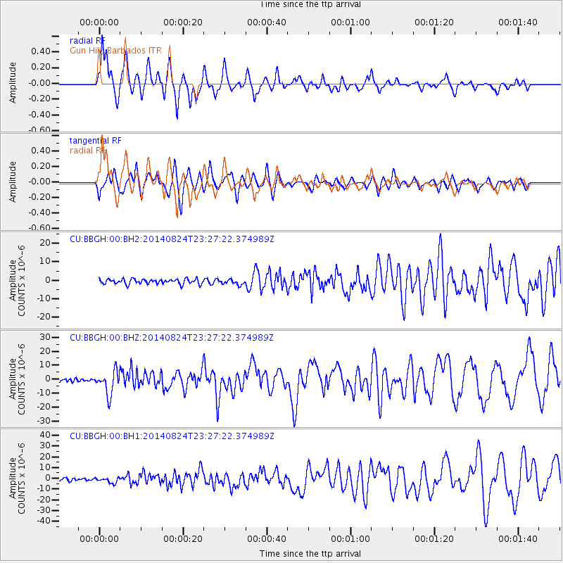
Signal To Noise
| Channel | StoN | STA | LTA |
| CU:BBGH:00:BHZ:20140824T23:27:22.374989Z | 6.25668 | 8.629651E-6 | 1.3792701E-6 |
| CU:BBGH:00:BH1:20140824T23:27:22.374989Z | 2.1996207 | 2.5382135E-6 | 1.1539324E-6 |
| CU:BBGH:00:BH2:20140824T23:27:22.374989Z | 1.075482 | 1.4234637E-6 | 1.3235588E-6 |
| Arrivals |
| Ps | 1.7 SECOND |
| PpPs | 6.4 SECOND |
| PsPs/PpSs | 8.1 SECOND |


