You are here: Home > Network List > TA - USArray Transportable Network (new EarthScope stations) Stations List
> Station G59A Clarenceville, QC, USA > Earthquake Result Viewer
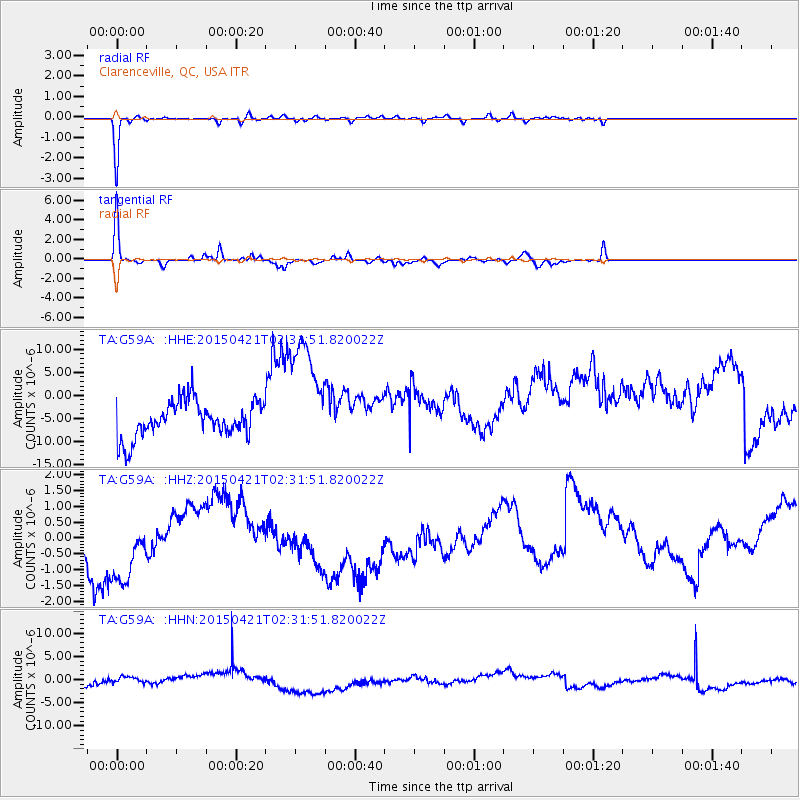
G59A Clarenceville, QC, USA - Earthquake Result Viewer
*The percent match for this event was below the threshold and hence no stack was calculated.
| Earthquake location: |
Hokkaido, Japan Region |
| Earthquake latitude/longitude: |
43.0/144.4 |
| Earthquake time(UTC): |
2015/04/21 (111) 02:19:52 GMT |
| Earthquake Depth: |
98 km |
| Earthquake Magnitude: |
3.4 mb |
| Earthquake Catalog/Contributor: |
ISC/ISC |
|
| Network: |
TA USArray Transportable Network (new EarthScope stations) |
| Station: |
G59A Clarenceville, QC, USA |
| Lat/Lon: |
45.08 N/73.18 W |
| Elevation: |
36 m |
|
| Distance: |
86.1 deg |
| Az: |
25.65 deg |
| Baz: |
333.365 deg |
| Ray Param: |
$rayparam |
*The percent match for this event was below the threshold and hence was not used in the summary stack. |
|
| Radial Match: |
93.738594 % |
| Radial Bump: |
199 |
| Transverse Match: |
79.55068 % |
| Transverse Bump: |
224 |
| SOD ConfigId: |
7422571 |
| Insert Time: |
2019-04-18 07:10:17.203 +0000 |
| GWidth: |
2.5 |
| Max Bumps: |
400 |
| Tol: |
0.001 |
|
Signal To Noise
| Channel | StoN | STA | LTA |
| TA:G59A: :HHZ:20150421T02:31:51.820022Z | 2.720424 | 1.75944E-6 | 6.4675214E-7 |
| TA:G59A: :HHN:20150421T02:31:51.820022Z | 0.7133956 | 6.498167E-7 | 9.1087844E-7 |
| TA:G59A: :HHE:20150421T02:31:51.820022Z | 3.3231406 | 1.3004402E-5 | 3.913287E-6 |
| Arrivals |
| Ps | |
| PpPs | |
| PsPs/PpSs | |


