You are here: Home > Network List > G - GEOSCOPE Stations List
> Station TAOE Taiohae, Marquises islands > Earthquake Result Viewer
TAOE Taiohae, Marquises islands - Earthquake Result Viewer
| Earthquake location: |
Central Peru |
| Earthquake latitude/longitude: |
-14.6/-73.6 |
| Earthquake time(UTC): |
2014/08/24 (236) 23:21:45 GMT |
| Earthquake Depth: |
101 km |
| Earthquake Magnitude: |
6.9 MWW, 6.8 MI, 6.9 MWB |
| Earthquake Catalog/Contributor: |
NEIC PDE/NEIC COMCAT |
|
| Network: |
G GEOSCOPE |
| Station: |
TAOE Taiohae, Marquises islands |
| Lat/Lon: |
8.85 S/140.15 W |
| Elevation: |
800 m |
|
| Distance: |
65.2 deg |
| Az: |
266.861 deg |
| Baz: |
101.976 deg |
| Ray Param: |
0.05812866 |
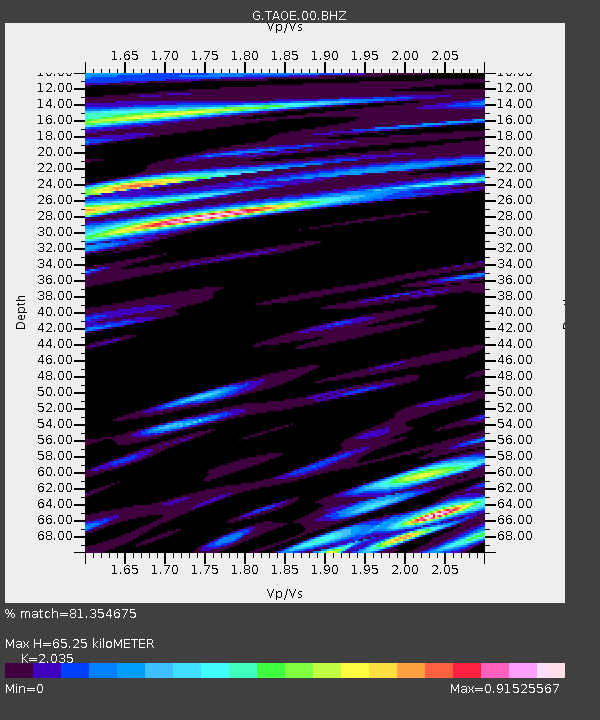
| Estimated Moho Depth: |
65.25 km |
| Estimated Crust Vp/Vs: |
2.04 |
| Assumed Crust Vp: |
4.24 km/s |
| Estimated Crust Vs: |
2.084 km/s |
| Estimated Crust Poisson's Ratio: |
0.34 |
|
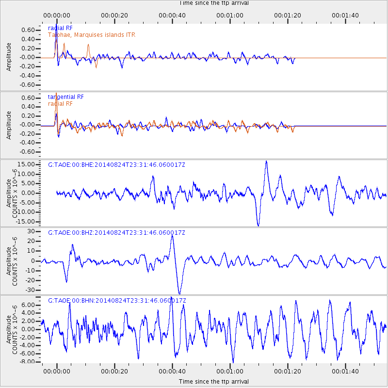
| Radial Match: |
81.354675 % |
| Radial Bump: |
400 |
| Transverse Match: |
80.05442 % |
| Transverse Bump: |
400 |
| SOD ConfigId: |
769524 |
| Insert Time: |
2014-09-07 23:41:34.736 +0000 |
| GWidth: |
2.5 |
| Max Bumps: |
400 |
| Tol: |
0.001 |
|
Signal To Noise
| Channel | StoN | STA | LTA |
| G:TAOE:00:BHZ:20140824T23:31:46.060017Z | 8.206734 | 7.875019E-6 | 9.595802E-7 |
| G:TAOE:00:BHN:20140824T23:31:46.060017Z | 3.0067854 | 2.9878759E-6 | 9.937111E-7 |
| G:TAOE:00:BHE:20140824T23:31:46.060017Z | 2.698897 | 3.6787058E-6 | 1.3630405E-6 |
| Arrivals |
| Ps | 16 SECOND |
| PpPs | 46 SECOND |
| PsPs/PpSs | 62 SECOND |


